You are here: Home > Network List > TA - USArray Transportable Network (new EarthScope stations) Stations List
> Station P11A Cicrle Ranch, Eureka, NV, USA > Earthquake Result Viewer
P11A Cicrle Ranch, Eureka, NV, USA - Earthquake Result Viewer

| Earthquake location: |
Santiago Del Estero Prov., Arg. |
| Earthquake latitude/longitude: |
-26.9/-63.1 |
| Earthquake time(UTC): |
2006/09/22 (265) 02:32:25 GMT |
| Earthquake Depth: |
598 km |
| Earthquake Magnitude: |
6.1 MB, 6.0 MW, 6.0 MW |
| Earthquake Catalog/Contributor: |
WHDF/NEIC |
|
| Network: |
TA USArray Transportable Network (new EarthScope stations) |
| Station: |
P11A Cicrle Ranch, Eureka, NV, USA |
| Lat/Lon: |
39.55 N/115.75 W |
| Elevation: |
1787 m |
|
| Distance: |
82.3 deg |
| Az: |
321.696 deg |
| Baz: |
134.262 deg |
| Ray Param: |
0.045191795 |
| Estimated Moho Depth: |
21.25 km |
| Estimated Crust Vp/Vs: |
2.08 |
| Assumed Crust Vp: |
6.276 km/s |
| Estimated Crust Vs: |
3.021 km/s |
| Estimated Crust Poisson's Ratio: |
0.35 |
|
| Radial Match: |
80.39073 % |
| Radial Bump: |
400 |
| Transverse Match: |
83.09693 % |
| Transverse Bump: |
400 |
| SOD ConfigId: |
2665 |
| Insert Time: |
2010-03-07 05:59:03.670 +0000 |
| GWidth: |
2.5 |
| Max Bumps: |
400 |
| Tol: |
0.001 |
|
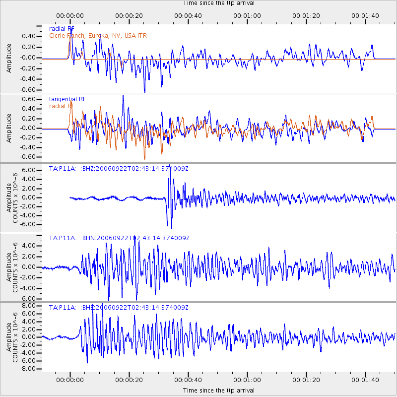
Signal To Noise
| Channel | StoN | STA | LTA |
| TA:P11A: :BHN:20060922T02:43:14.374009Z | 2.8250673 | 6.227198E-7 | 2.2042654E-7 |
| TA:P11A: :BHE:20060922T02:43:14.374009Z | 5.73603 | 1.4097949E-6 | 2.4577884E-7 |
| TA:P11A: :BHZ:20060922T02:43:14.374009Z | 12.897557 | 3.1182958E-6 | 2.4177413E-7 |
| Arrivals |
| Ps | 3.7 SECOND |
| PpPs | 10 SECOND |
| PsPs/PpSs | 14 SECOND |


