You are here: Home > Network List > TA - USArray Transportable Network (new EarthScope stations) Stations List
> Station P11A Cicrle Ranch, Eureka, NV, USA > Earthquake Result Viewer
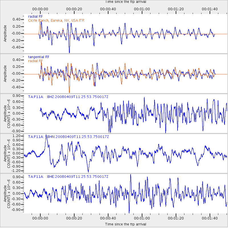
P11A Cicrle Ranch, Eureka, NV, USA - Earthquake Result Viewer
*The percent match for this event was below the threshold and hence no stack was calculated.
| Earthquake location: |
Loyalty Islands |
| Earthquake latitude/longitude: |
-20.2/168.9 |
| Earthquake time(UTC): |
2008/04/09 (100) 11:13:17 GMT |
| Earthquake Depth: |
13 km |
| Earthquake Magnitude: |
5.6 MB, 6.3 MS, 6.4 MW, 6.3 MW |
| Earthquake Catalog/Contributor: |
WHDF/NEIC |
|
| Network: |
TA USArray Transportable Network (new EarthScope stations) |
| Station: |
P11A Cicrle Ranch, Eureka, NV, USA |
| Lat/Lon: |
39.55 N/115.75 W |
| Elevation: |
1787 m |
|
| Distance: |
92.0 deg |
| Az: |
48.465 deg |
| Baz: |
245.44 deg |
| Ray Param: |
$rayparam |
*The percent match for this event was below the threshold and hence was not used in the summary stack. |
|
| Radial Match: |
70.060844 % |
| Radial Bump: |
400 |
| Transverse Match: |
61.94155 % |
| Transverse Bump: |
400 |
| SOD ConfigId: |
2504 |
| Insert Time: |
2010-03-07 06:00:01.595 +0000 |
| GWidth: |
2.5 |
| Max Bumps: |
400 |
| Tol: |
0.001 |
|
Signal To Noise
| Channel | StoN | STA | LTA |
| TA:P11A: :BHN:20080409T11:25:53.750017Z | 4.5434055 | 5.7414593E-7 | 1.2636907E-7 |
| TA:P11A: :BHE:20080409T11:25:53.750017Z | 0.7715388 | 1.4911662E-7 | 1.9327172E-7 |
| TA:P11A: :BHZ:20080409T11:25:53.750017Z | 1.4292864 | 2.0716641E-7 | 1.4494395E-7 |
| Arrivals |
| Ps | |
| PpPs | |
| PsPs/PpSs | |


