You are here: Home > Network List > TA - USArray Transportable Network (new EarthScope stations) Stations List
> Station P11A Cicrle Ranch, Eureka, NV, USA > Earthquake Result Viewer
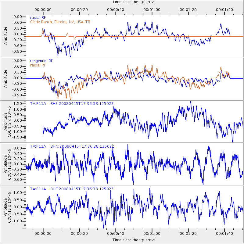
P11A Cicrle Ranch, Eureka, NV, USA - Earthquake Result Viewer
*The percent match for this event was below the threshold and hence no stack was calculated.
| Earthquake location: |
Tonga Islands |
| Earthquake latitude/longitude: |
-18.7/-176.0 |
| Earthquake time(UTC): |
2008/04/15 (106) 17:24:56 GMT |
| Earthquake Depth: |
10 km |
| Earthquake Magnitude: |
5.5 MB, 5.5 MS, 5.7 MW, 5.6 MW |
| Earthquake Catalog/Contributor: |
WHDF/NEIC |
|
| Network: |
TA USArray Transportable Network (new EarthScope stations) |
| Station: |
P11A Cicrle Ranch, Eureka, NV, USA |
| Lat/Lon: |
39.55 N/115.75 W |
| Elevation: |
1787 m |
|
| Distance: |
80.7 deg |
| Az: |
42.837 deg |
| Baz: |
236.471 deg |
| Ray Param: |
$rayparam |
*The percent match for this event was below the threshold and hence was not used in the summary stack. |
|
| Radial Match: |
50.23422 % |
| Radial Bump: |
400 |
| Transverse Match: |
55.452545 % |
| Transverse Bump: |
400 |
| SOD ConfigId: |
2504 |
| Insert Time: |
2010-03-07 06:00:03.804 +0000 |
| GWidth: |
2.5 |
| Max Bumps: |
400 |
| Tol: |
0.001 |
|
Signal To Noise
| Channel | StoN | STA | LTA |
| TA:P11A: :BHN:20080415T17:36:38.12502Z | 0.9470207 | 1.7378959E-7 | 1.8351191E-7 |
| TA:P11A: :BHE:20080415T17:36:38.12502Z | 0.9749633 | 3.649217E-7 | 3.7429277E-7 |
| TA:P11A: :BHZ:20080415T17:36:38.12502Z | 1.1596711 | 5.380552E-7 | 4.639722E-7 |
| Arrivals |
| Ps | |
| PpPs | |
| PsPs/PpSs | |


