You are here: Home > Network List > US - United States National Seismic Network Stations List
> Station MNTX Cornudas Mountains, Texas, USA > Earthquake Result Viewer
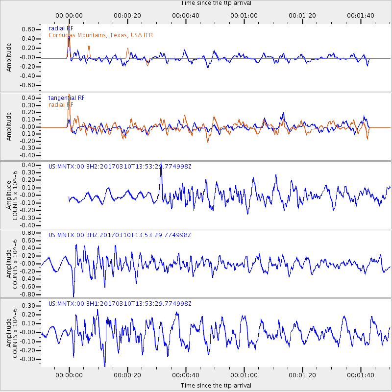
MNTX Cornudas Mountains, Texas, USA - Earthquake Result Viewer
*The percent match for this event was below the threshold and hence no stack was calculated.
| Earthquake location: |
Near Coast Of Venezuela |
| Earthquake latitude/longitude: |
12.0/-69.6 |
| Earthquake time(UTC): |
2017/03/10 (069) 13:46:39 GMT |
| Earthquake Depth: |
10 km |
| Earthquake Magnitude: |
5.5 mb |
| Earthquake Catalog/Contributor: |
NEIC PDE/us |
|
| Network: |
US United States National Seismic Network |
| Station: |
MNTX Cornudas Mountains, Texas, USA |
| Lat/Lon: |
31.70 N/105.38 W |
| Elevation: |
404 m |
|
| Distance: |
38.3 deg |
| Az: |
306.535 deg |
| Baz: |
112.715 deg |
| Ray Param: |
$rayparam |
*The percent match for this event was below the threshold and hence was not used in the summary stack. |
|
| Radial Match: |
58.36927 % |
| Radial Bump: |
385 |
| Transverse Match: |
62.17462 % |
| Transverse Bump: |
400 |
| SOD ConfigId: |
1992691 |
| Insert Time: |
2017-03-24 13:53:19.369 +0000 |
| GWidth: |
2.5 |
| Max Bumps: |
400 |
| Tol: |
0.001 |
|
Signal To Noise
| Channel | StoN | STA | LTA |
| US:MNTX:00:BHZ:20170310T13:53:29.774998Z | 2.1919527 | 2.8919553E-7 | 1.3193511E-7 |
| US:MNTX:00:BH1:20170310T13:53:29.774998Z | 1.0319134 | 9.9796345E-8 | 9.6710004E-8 |
| US:MNTX:00:BH2:20170310T13:53:29.774998Z | 2.9546983 | 1.3561534E-7 | 4.58982E-8 |
| Arrivals |
| Ps | |
| PpPs | |
| PsPs/PpSs | |


