You are here: Home > Network List > TS - TERRAscope (Southern California Seismic Network) Stations List
> Station PAS Pasadena, California, USA > Earthquake Result Viewer
PAS Pasadena, California, USA - Earthquake Result Viewer
| Earthquake location: |
Southeast Of Honshu, Japan |
| Earthquake latitude/longitude: |
33.2/138.0 |
| Earthquake time(UTC): |
1992/08/29 (242) 19:19:07 GMT |
| Earthquake Depth: |
309 km |
| Earthquake Magnitude: |
6.0 MB |
| Earthquake Catalog/Contributor: |
WHDF/NEIC |
|
| Network: |
TS TERRAscope (Southern California Seismic Network) |
| Station: |
PAS Pasadena, California, USA |
| Lat/Lon: |
34.15 N/118.17 W |
| Elevation: |
295 m |
|
| Distance: |
82.1 deg |
| Az: |
54.406 deg |
| Baz: |
304.665 deg |
| Ray Param: |
0.046349086 |
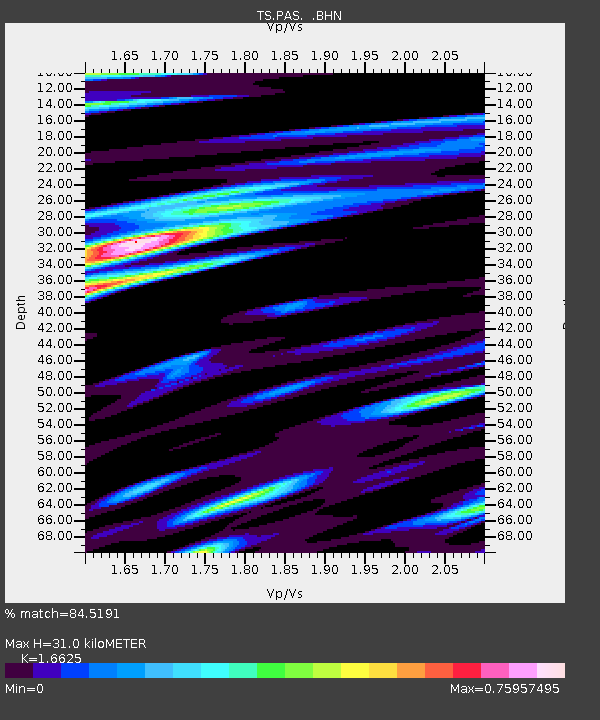
| Estimated Moho Depth: |
31.0 km |
| Estimated Crust Vp/Vs: |
1.66 |
| Assumed Crust Vp: |
6.1 km/s |
| Estimated Crust Vs: |
3.669 km/s |
| Estimated Crust Poisson's Ratio: |
0.22 |
|
| Radial Match: |
84.5191 % |
| Radial Bump: |
400 |
| Transverse Match: |
83.32984 % |
| Transverse Bump: |
400 |
| SOD ConfigId: |
16938 |
| Insert Time: |
2010-02-26 14:34:55.977 +0000 |
| GWidth: |
2.5 |
| Max Bumps: |
400 |
| Tol: |
0.001 |
|
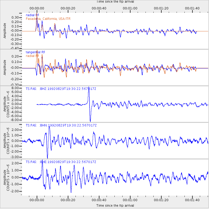
Signal To Noise
| Channel | StoN | STA | LTA |
| TS:PAS: :BHN:19920829T19:30:22.567017Z | 2.7380888 | 4.0892914E-7 | 1.4934838E-7 |
| TS:PAS: :BHE:19920829T19:30:22.567017Z | 6.406166 | 8.781188E-7 | 1.37074E-7 |
| TS:PAS: :BHZ:19920829T19:30:22.567017Z | 20.737463 | 3.862644E-6 | 1.8626406E-7 |
| Arrivals |
| Ps | 3.5 SECOND |
| PpPs | 13 SECOND |
| PsPs/PpSs | 17 SECOND |


