You are here: Home > Network List > CN - Canadian National Seismograph Network Stations List
> Station HG1B Mitchell Dam, BC, CA > Earthquake Result Viewer
HG1B Mitchell Dam, BC, CA - Earthquake Result Viewer
| Earthquake location: |
Off Coast Of Chiapas, Mexico |
| Earthquake latitude/longitude: |
14.0/-93.1 |
| Earthquake time(UTC): |
2019/11/20 (324) 04:27:07 GMT |
| Earthquake Depth: |
26 km |
| Earthquake Magnitude: |
6.3 Mww |
| Earthquake Catalog/Contributor: |
NEIC PDE/us |
|
| Network: |
CN Canadian National Seismograph Network |
| Station: |
HG1B Mitchell Dam, BC, CA |
| Lat/Lon: |
52.93 N/132.13 W |
| Elevation: |
5.0 m |
|
| Distance: |
49.6 deg |
| Az: |
330.018 deg |
| Baz: |
126.723 deg |
| Ray Param: |
0.0685254 |
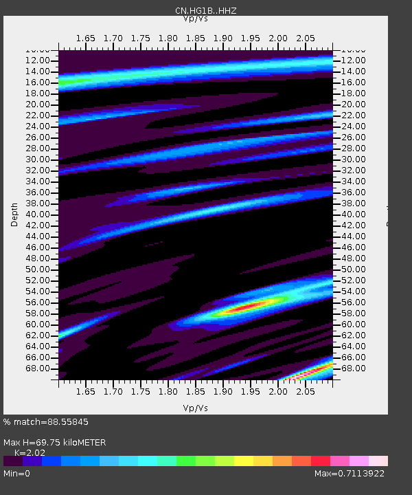
| Estimated Moho Depth: |
69.75 km |
| Estimated Crust Vp/Vs: |
2.02 |
| Assumed Crust Vp: |
6.183 km/s |
| Estimated Crust Vs: |
3.061 km/s |
| Estimated Crust Poisson's Ratio: |
0.34 |
|
| Radial Match: |
88.55845 % |
| Radial Bump: |
348 |
| Transverse Match: |
70.278915 % |
| Transverse Bump: |
400 |
| SOD ConfigId: |
19951751 |
| Insert Time: |
2019-12-04 04:44:34.473 +0000 |
| GWidth: |
2.5 |
| Max Bumps: |
400 |
| Tol: |
0.001 |
|

Signal To Noise
| Channel | StoN | STA | LTA |
| CN:HG1B: :HHZ:20191120T04:35:26.23001Z | 9.829817 | 3.1210934E-6 | 3.1751284E-7 |
| CN:HG1B: :HHN:20191120T04:35:26.23001Z | 3.9759223 | 1.3228238E-6 | 3.3270865E-7 |
| CN:HG1B: :HHE:20191120T04:35:26.23001Z | 5.5434756 | 1.4983042E-6 | 2.7028247E-7 |
| Arrivals |
| Ps | 12 SECOND |
| PpPs | 33 SECOND |
| PsPs/PpSs | 45 SECOND |


