You are here: Home > Network List > TA - USArray Transportable Network (new EarthScope stations) Stations List
> Station K13A Stover Farm, Hazelton, ID, USA > Earthquake Result Viewer
K13A Stover Farm, Hazelton, ID, USA - Earthquake Result Viewer
| Earthquake location: |
Andreanof Islands, Aleutian Is. |
| Earthquake latitude/longitude: |
51.4/-179.5 |
| Earthquake time(UTC): |
2007/12/19 (353) 09:30:27 GMT |
| Earthquake Depth: |
29 km |
| Earthquake Magnitude: |
6.4 MB, 7.1 MS, 7.1 MW, 7.0 MW |
| Earthquake Catalog/Contributor: |
WHDF/NEIC |
|
| Network: |
TA USArray Transportable Network (new EarthScope stations) |
| Station: |
K13A Stover Farm, Hazelton, ID, USA |
| Lat/Lon: |
42.65 N/114.08 W |
| Elevation: |
1222 m |
|
| Distance: |
44.1 deg |
| Az: |
74.643 deg |
| Baz: |
304.972 deg |
| Ray Param: |
0.07207352 |
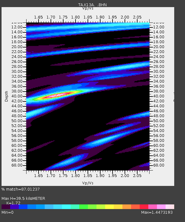
| Estimated Moho Depth: |
39.5 km |
| Estimated Crust Vp/Vs: |
1.72 |
| Assumed Crust Vp: |
6.291 km/s |
| Estimated Crust Vs: |
3.658 km/s |
| Estimated Crust Poisson's Ratio: |
0.24 |
|
| Radial Match: |
87.01237 % |
| Radial Bump: |
336 |
| Transverse Match: |
73.14225 % |
| Transverse Bump: |
400 |
| SOD ConfigId: |
2564 |
| Insert Time: |
2010-03-07 06:00:56.676 +0000 |
| GWidth: |
2.5 |
| Max Bumps: |
400 |
| Tol: |
0.001 |
|

Signal To Noise
| Channel | StoN | STA | LTA |
| TA:K13A: :BHN:20071219T09:38:02.124014Z | 1.1867751 | 4.4383242E-7 | 3.7398192E-7 |
| TA:K13A: :BHE:20071219T09:38:02.124014Z | 5.0961065 | 2.254213E-6 | 4.4234028E-7 |
| TA:K13A: :BHZ:20071219T09:38:02.124014Z | 5.0677166 | 3.3985073E-6 | 6.7061904E-7 |
| Arrivals |
| Ps | 4.8 SECOND |
| PpPs | 16 SECOND |
| PsPs/PpSs | 21 SECOND |


