You are here: Home > Network List > TS - TERRAscope (Southern California Seismic Network) Stations List
> Station PAS Pasadena, California, USA > Earthquake Result Viewer
PAS Pasadena, California, USA - Earthquake Result Viewer

| Earthquake location: |
Vanuatu Islands |
| Earthquake latitude/longitude: |
-19.3/169.5 |
| Earthquake time(UTC): |
1992/10/17 (291) 02:51:53 GMT |
| Earthquake Depth: |
33 km |
| Earthquake Magnitude: |
5.7 MB, 6.5 MS, 7.0 UNKNOWN |
| Earthquake Catalog/Contributor: |
WHDF/NEIC |
|
| Network: |
TS TERRAscope (Southern California Seismic Network) |
| Station: |
PAS Pasadena, California, USA |
| Lat/Lon: |
34.15 N/118.17 W |
| Elevation: |
295 m |
|
| Distance: |
86.8 deg |
| Az: |
52.298 deg |
| Baz: |
244.328 deg |
| Ray Param: |
0.043721385 |
| Estimated Moho Depth: |
58.0 km |
| Estimated Crust Vp/Vs: |
1.84 |
| Assumed Crust Vp: |
6.1 km/s |
| Estimated Crust Vs: |
3.324 km/s |
| Estimated Crust Poisson's Ratio: |
0.29 |
|
| Radial Match: |
88.231384 % |
| Radial Bump: |
395 |
| Transverse Match: |
80.04949 % |
| Transverse Bump: |
400 |
| SOD ConfigId: |
16938 |
| Insert Time: |
2010-02-26 14:34:59.227 +0000 |
| GWidth: |
2.5 |
| Max Bumps: |
400 |
| Tol: |
0.001 |
|
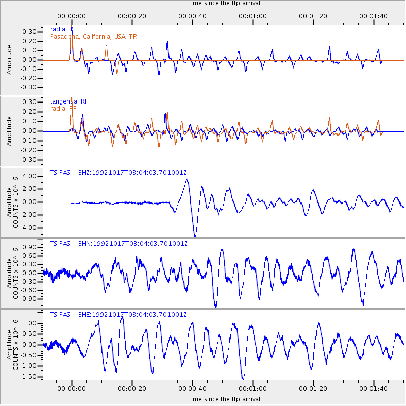
Signal To Noise
| Channel | StoN | STA | LTA |
| TS:PAS: :BHN:19921017T03:04:03.701001Z | 0.55955476 | 8.7264944E-8 | 1.5595425E-7 |
| TS:PAS: :BHE:19921017T03:04:03.701001Z | 2.2901974 | 2.929779E-7 | 1.2792692E-7 |
| TS:PAS: :BHZ:19921017T03:04:03.701001Z | 7.9303865 | 5.995698E-7 | 7.5604106E-8 |
| Arrivals |
| Ps | 8.1 SECOND |
| PpPs | 26 SECOND |
| PsPs/PpSs | 35 SECOND |


