You are here: Home > Network List > TS - TERRAscope (Southern California Seismic Network) Stations List
> Station PAS Pasadena, California, USA > Earthquake Result Viewer
PAS Pasadena, California, USA - Earthquake Result Viewer
| Earthquake location: |
Northern Colombia |
| Earthquake latitude/longitude: |
6.9/-76.8 |
| Earthquake time(UTC): |
1992/10/17 (291) 08:32:39 GMT |
| Earthquake Depth: |
10 km |
| Earthquake Magnitude: |
6.2 MB, 6.7 MS, 7.0 UNKNOWN |
| Earthquake Catalog/Contributor: |
WHDF/NEIC |
|
| Network: |
TS TERRAscope (Southern California Seismic Network) |
| Station: |
PAS Pasadena, California, USA |
| Lat/Lon: |
34.15 N/118.17 W |
| Elevation: |
295 m |
|
| Distance: |
46.8 deg |
| Az: |
311.269 deg |
| Baz: |
115.857 deg |
| Ray Param: |
0.07041066 |
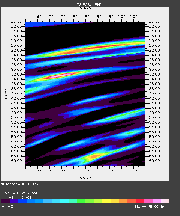
| Estimated Moho Depth: |
32.25 km |
| Estimated Crust Vp/Vs: |
1.75 |
| Assumed Crust Vp: |
6.1 km/s |
| Estimated Crust Vs: |
3.491 km/s |
| Estimated Crust Poisson's Ratio: |
0.26 |
|
| Radial Match: |
96.32974 % |
| Radial Bump: |
299 |
| Transverse Match: |
84.03235 % |
| Transverse Bump: |
400 |
| SOD ConfigId: |
16938 |
| Insert Time: |
2010-02-26 14:35:00.525 +0000 |
| GWidth: |
2.5 |
| Max Bumps: |
400 |
| Tol: |
0.001 |
|

Signal To Noise
| Channel | StoN | STA | LTA |
| TS:PAS: :BHN:19921017T08:40:38.695013Z | 1.3666865 | 1.7385501E-7 | 1.2720915E-7 |
| TS:PAS: :BHE:19921017T08:40:38.695013Z | 3.589945 | 3.292654E-7 | 9.171878E-8 |
| TS:PAS: :BHZ:19921017T08:40:38.695013Z | 7.237574 | 6.715138E-7 | 9.278161E-8 |
| Arrivals |
| Ps | 4.2 SECOND |
| PpPs | 14 SECOND |
| PsPs/PpSs | 18 SECOND |


