You are here: Home > Network List > TA - USArray Transportable Network (new EarthScope stations) Stations List
> Station K13A Stover Farm, Hazelton, ID, USA > Earthquake Result Viewer
K13A Stover Farm, Hazelton, ID, USA - Earthquake Result Viewer
| Earthquake location: |
Santa Cruz Islands |
| Earthquake latitude/longitude: |
-11.4/166.3 |
| Earthquake time(UTC): |
2007/08/12 (224) 12:05:19 GMT |
| Earthquake Depth: |
42 km |
| Earthquake Magnitude: |
5.8 MB, 5.7 MS, 6.0 MW, 6.0 MW |
| Earthquake Catalog/Contributor: |
WHDF/NEIC |
|
| Network: |
TA USArray Transportable Network (new EarthScope stations) |
| Station: |
K13A Stover Farm, Hazelton, ID, USA |
| Lat/Lon: |
42.65 N/114.08 W |
| Elevation: |
1222 m |
|
| Distance: |
90.1 deg |
| Az: |
46.532 deg |
| Baz: |
254.715 deg |
| Ray Param: |
0.04168946 |
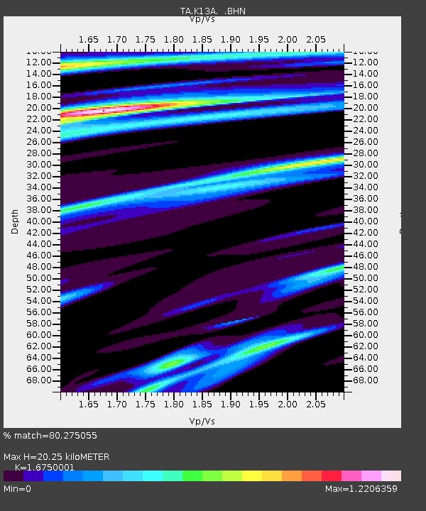
| Estimated Moho Depth: |
20.25 km |
| Estimated Crust Vp/Vs: |
1.68 |
| Assumed Crust Vp: |
6.291 km/s |
| Estimated Crust Vs: |
3.756 km/s |
| Estimated Crust Poisson's Ratio: |
0.22 |
|
| Radial Match: |
80.275055 % |
| Radial Bump: |
290 |
| Transverse Match: |
64.430595 % |
| Transverse Bump: |
400 |
| SOD ConfigId: |
2564 |
| Insert Time: |
2010-03-07 06:01:19.581 +0000 |
| GWidth: |
2.5 |
| Max Bumps: |
400 |
| Tol: |
0.001 |
|
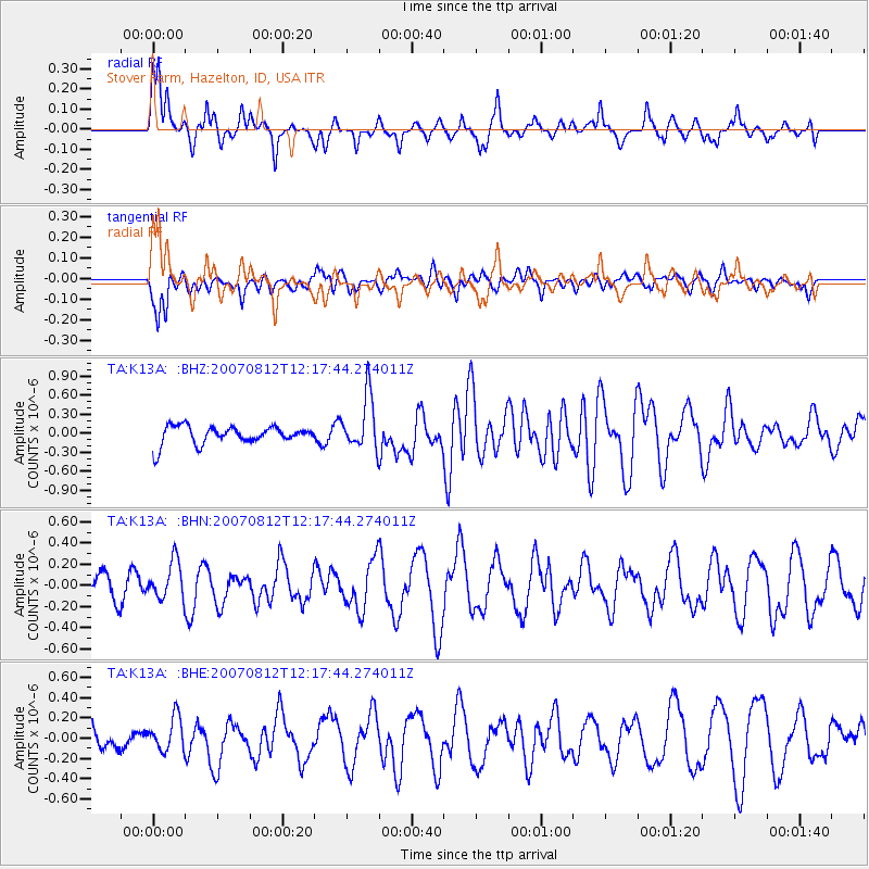
Signal To Noise
| Channel | StoN | STA | LTA |
| TA:K13A: :BHN:20070812T12:17:44.274011Z | 1.481902 | 1.8158099E-7 | 1.2253238E-7 |
| TA:K13A: :BHE:20070812T12:17:44.274011Z | 0.9557039 | 1.6977377E-7 | 1.7764265E-7 |
| TA:K13A: :BHZ:20070812T12:17:44.274011Z | 3.012925 | 4.2700952E-7 | 1.417259E-7 |
| Arrivals |
| Ps | 2.2 SECOND |
| PpPs | 8.4 SECOND |
| PsPs/PpSs | 11 SECOND |


