You are here: Home > Network List > IW - Intermountain West Stations List
> Station PLID Pearl Lake, Idaho, USA > Earthquake Result Viewer
PLID Pearl Lake, Idaho, USA - Earthquake Result Viewer
| Earthquake location: |
Off Coast Of Chiapas, Mexico |
| Earthquake latitude/longitude: |
14.0/-93.1 |
| Earthquake time(UTC): |
2019/11/20 (324) 04:27:07 GMT |
| Earthquake Depth: |
26 km |
| Earthquake Magnitude: |
6.3 Mww |
| Earthquake Catalog/Contributor: |
NEIC PDE/us |
|
| Network: |
IW Intermountain West |
| Station: |
PLID Pearl Lake, Idaho, USA |
| Lat/Lon: |
45.09 N/116.00 W |
| Elevation: |
2164 m |
|
| Distance: |
36.6 deg |
| Az: |
332.512 deg |
| Baz: |
140.76 deg |
| Ray Param: |
0.0765532 |
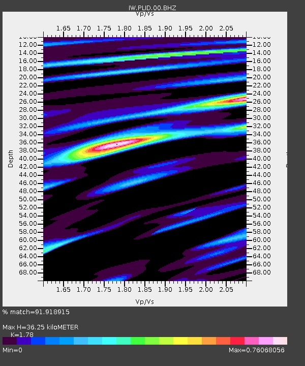
| Estimated Moho Depth: |
36.25 km |
| Estimated Crust Vp/Vs: |
1.78 |
| Assumed Crust Vp: |
6.571 km/s |
| Estimated Crust Vs: |
3.691 km/s |
| Estimated Crust Poisson's Ratio: |
0.27 |
|
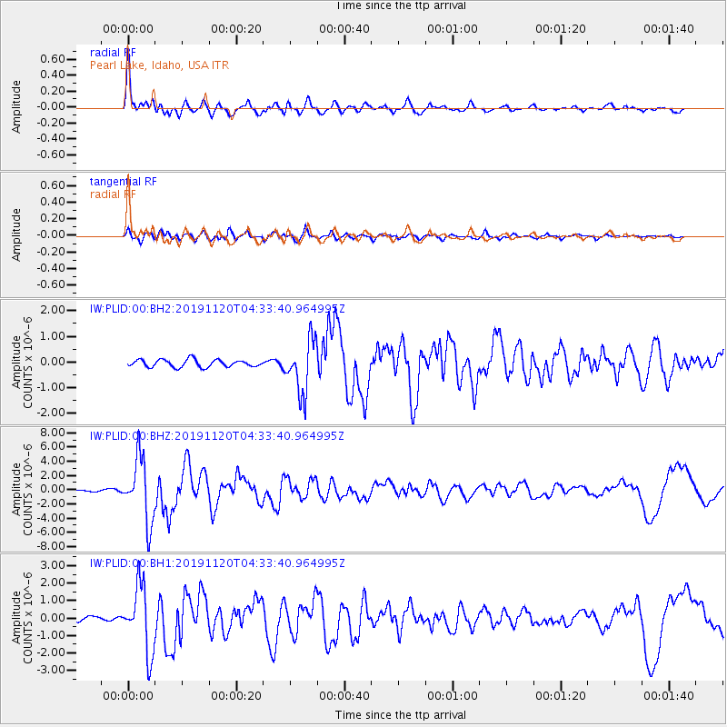
| Radial Match: |
91.918915 % |
| Radial Bump: |
400 |
| Transverse Match: |
85.191734 % |
| Transverse Bump: |
400 |
| SOD ConfigId: |
19951751 |
| Insert Time: |
2019-12-04 04:46:46.815 +0000 |
| GWidth: |
2.5 |
| Max Bumps: |
400 |
| Tol: |
0.001 |
|
Signal To Noise
| Channel | StoN | STA | LTA |
| IW:PLID:00:BHZ:20191120T04:33:40.964995Z | 43.5845 | 4.4961216E-6 | 1.0315873E-7 |
| IW:PLID:00:BH1:20191120T04:33:40.964995Z | 19.457502 | 1.9137171E-6 | 9.835369E-8 |
| IW:PLID:00:BH2:20191120T04:33:40.964995Z | 7.221199 | 1.0386557E-6 | 1.4383424E-7 |
| Arrivals |
| Ps | 4.7 SECOND |
| PpPs | 14 SECOND |
| PsPs/PpSs | 19 SECOND |


