You are here: Home > Network List > TA - USArray Transportable Network (new EarthScope stations) Stations List
> Station K13A Stover Farm, Hazelton, ID, USA > Earthquake Result Viewer
K13A Stover Farm, Hazelton, ID, USA - Earthquake Result Viewer
| Earthquake location: |
Chile-Argentina Border Region |
| Earthquake latitude/longitude: |
-24.2/-67.0 |
| Earthquake time(UTC): |
2007/05/25 (145) 17:47:31 GMT |
| Earthquake Depth: |
180 km |
| Earthquake Magnitude: |
5.5 MB, 5.9 MW, 5.9 MW |
| Earthquake Catalog/Contributor: |
WHDF/NEIC |
|
| Network: |
TA USArray Transportable Network (new EarthScope stations) |
| Station: |
K13A Stover Farm, Hazelton, ID, USA |
| Lat/Lon: |
42.65 N/114.08 W |
| Elevation: |
1222 m |
|
| Distance: |
79.4 deg |
| Az: |
326.674 deg |
| Baz: |
137.166 deg |
| Ray Param: |
0.04852244 |
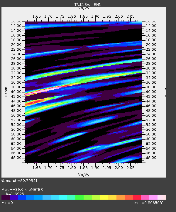
| Estimated Moho Depth: |
39.0 km |
| Estimated Crust Vp/Vs: |
1.69 |
| Assumed Crust Vp: |
6.291 km/s |
| Estimated Crust Vs: |
3.717 km/s |
| Estimated Crust Poisson's Ratio: |
0.23 |
|
| Radial Match: |
80.79941 % |
| Radial Bump: |
400 |
| Transverse Match: |
51.647404 % |
| Transverse Bump: |
400 |
| SOD ConfigId: |
2564 |
| Insert Time: |
2010-03-07 06:01:35.522 +0000 |
| GWidth: |
2.5 |
| Max Bumps: |
400 |
| Tol: |
0.001 |
|
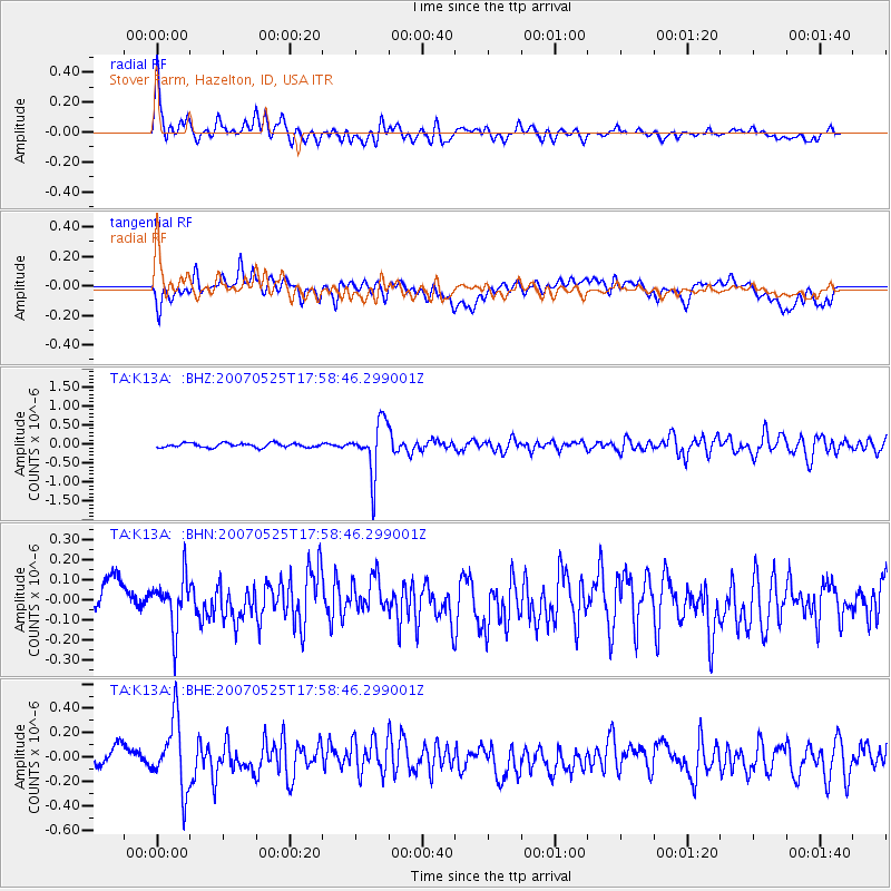
Signal To Noise
| Channel | StoN | STA | LTA |
| TA:K13A: :BHN:20070525T17:58:46.299001Z | 1.1900314 | 1.3059535E-7 | 1.09741094E-7 |
| TA:K13A: :BHE:20070525T17:58:46.299001Z | 3.0961835 | 2.8620792E-7 | 9.243894E-8 |
| TA:K13A: :BHZ:20070525T17:58:46.299001Z | 11.926121 | 6.7191206E-7 | 5.6339534E-8 |
| Arrivals |
| Ps | 4.4 SECOND |
| PpPs | 16 SECOND |
| PsPs/PpSs | 21 SECOND |


