You are here: Home > Network List > TS - TERRAscope (Southern California Seismic Network) Stations List
> Station PAS Pasadena, California, USA > Earthquake Result Viewer
PAS Pasadena, California, USA - Earthquake Result Viewer
| Earthquake location: |
Northern Colombia |
| Earthquake latitude/longitude: |
7.1/-76.9 |
| Earthquake time(UTC): |
1992/10/18 (292) 15:11:59 GMT |
| Earthquake Depth: |
10 km |
| Earthquake Magnitude: |
6.6 MB, 7.3 MS, 7.4 UNKNOWN |
| Earthquake Catalog/Contributor: |
WHDF/NEIC |
|
| Network: |
TS TERRAscope (Southern California Seismic Network) |
| Station: |
PAS Pasadena, California, USA |
| Lat/Lon: |
34.15 N/118.17 W |
| Elevation: |
295 m |
|
| Distance: |
46.6 deg |
| Az: |
311.123 deg |
| Baz: |
115.657 deg |
| Ray Param: |
0.07055308 |
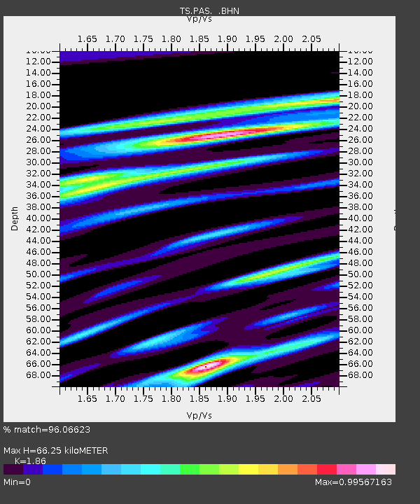
| Estimated Moho Depth: |
66.25 km |
| Estimated Crust Vp/Vs: |
1.86 |
| Assumed Crust Vp: |
6.1 km/s |
| Estimated Crust Vs: |
3.28 km/s |
| Estimated Crust Poisson's Ratio: |
0.30 |
|
| Radial Match: |
96.06623 % |
| Radial Bump: |
357 |
| Transverse Match: |
88.605194 % |
| Transverse Bump: |
400 |
| SOD ConfigId: |
16938 |
| Insert Time: |
2010-02-26 14:35:01.969 +0000 |
| GWidth: |
2.5 |
| Max Bumps: |
400 |
| Tol: |
0.001 |
|
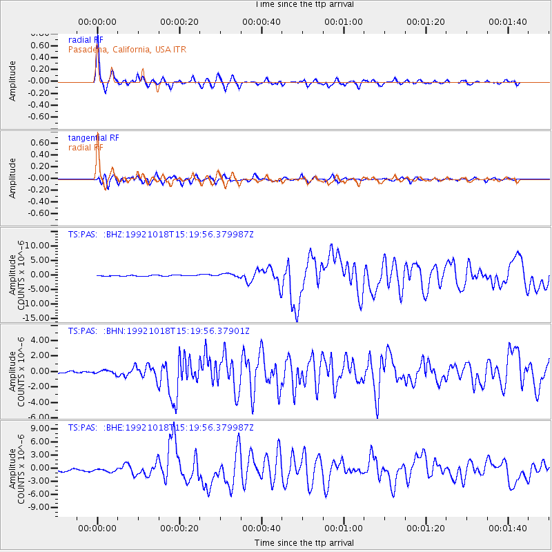
Signal To Noise
| Channel | StoN | STA | LTA |
| TS:PAS: :BHN:19921018T15:19:56.37901Z | 1.8074034 | 2.3126213E-7 | 1.2795269E-7 |
| TS:PAS: :BHE:19921018T15:19:56.379987Z | 1.7178677 | 3.4251008E-7 | 1.9938093E-7 |
| TS:PAS: :BHZ:19921018T15:19:56.379987Z | 3.728979 | 5.855368E-7 | 1.5702334E-7 |
| Arrivals |
| Ps | 9.8 SECOND |
| PpPs | 29 SECOND |
| PsPs/PpSs | 39 SECOND |


