You are here: Home > Network List > TA - USArray Transportable Network (new EarthScope stations) Stations List
> Station K13A Stover Farm, Hazelton, ID, USA > Earthquake Result Viewer
K13A Stover Farm, Hazelton, ID, USA - Earthquake Result Viewer
| Earthquake location: |
Solomon Islands |
| Earthquake latitude/longitude: |
-8.5/157.0 |
| Earthquake time(UTC): |
2007/04/01 (091) 20:39:56 GMT |
| Earthquake Depth: |
10 km |
| Earthquake Magnitude: |
6.8 MB, 7.9 MS, 8.1 MW, 7.7 ME |
| Earthquake Catalog/Contributor: |
WHDF/NEIC |
|
| Network: |
TA USArray Transportable Network (new EarthScope stations) |
| Station: |
K13A Stover Farm, Hazelton, ID, USA |
| Lat/Lon: |
42.65 N/114.08 W |
| Elevation: |
1222 m |
|
| Distance: |
94.8 deg |
| Az: |
47.754 deg |
| Baz: |
263.027 deg |
| Ray Param: |
0.040942375 |
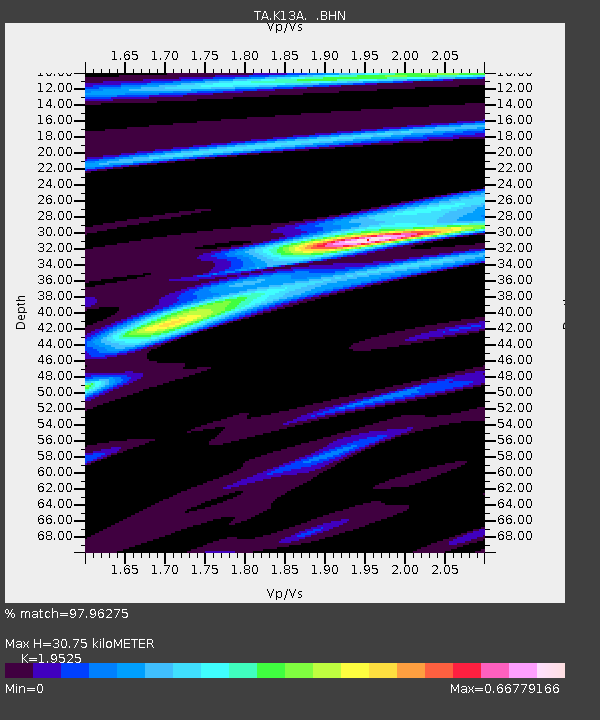
| Estimated Moho Depth: |
30.75 km |
| Estimated Crust Vp/Vs: |
1.95 |
| Assumed Crust Vp: |
6.291 km/s |
| Estimated Crust Vs: |
3.222 km/s |
| Estimated Crust Poisson's Ratio: |
0.32 |
|
| Radial Match: |
97.96275 % |
| Radial Bump: |
306 |
| Transverse Match: |
95.41625 % |
| Transverse Bump: |
400 |
| SOD ConfigId: |
2564 |
| Insert Time: |
2010-03-07 06:01:39.317 +0000 |
| GWidth: |
2.5 |
| Max Bumps: |
400 |
| Tol: |
0.001 |
|
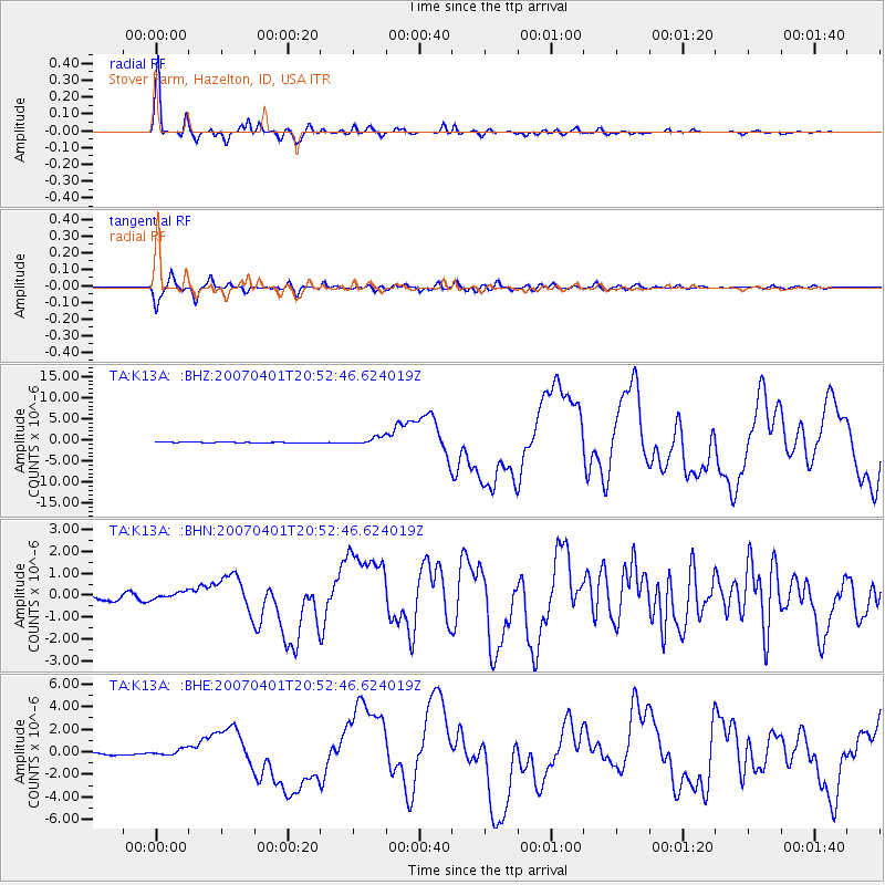
Signal To Noise
| Channel | StoN | STA | LTA |
| TA:K13A: :BHN:20070401T20:52:46.624019Z | 1.807973 | 1.7541137E-7 | 9.7021015E-8 |
| TA:K13A: :BHE:20070401T20:52:46.624019Z | 2.707384 | 2.9127955E-7 | 1.0758708E-7 |
| TA:K13A: :BHZ:20070401T20:52:46.624019Z | 6.843008 | 9.183619E-7 | 1.3420441E-7 |
| Arrivals |
| Ps | 4.7 SECOND |
| PpPs | 14 SECOND |
| PsPs/PpSs | 19 SECOND |


