You are here: Home > Network List > TA - USArray Transportable Network (new EarthScope stations) Stations List
> Station K13A Stover Farm, Hazelton, ID, USA > Earthquake Result Viewer
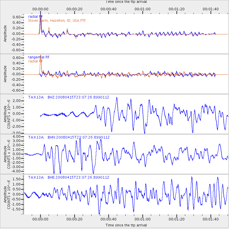
K13A Stover Farm, Hazelton, ID, USA - Earthquake Result Viewer
| Earthquake location: |
Andreanof Islands, Aleutian Is. |
| Earthquake latitude/longitude: |
51.9/-179.4 |
| Earthquake time(UTC): |
2008/04/15 (106) 22:59:51 GMT |
| Earthquake Depth: |
10 km |
| Earthquake Magnitude: |
6.1 MB, 6.4 MS, 6.4 MW, 6.4 MW |
| Earthquake Catalog/Contributor: |
WHDF/NEIC |
|
| Network: |
TA USArray Transportable Network (new EarthScope stations) |
| Station: |
K13A Stover Farm, Hazelton, ID, USA |
| Lat/Lon: |
42.65 N/114.08 W |
| Elevation: |
1222 m |
|
| Distance: |
43.9 deg |
| Az: |
75.235 deg |
| Baz: |
305.618 deg |
| Ray Param: |
0.07227132 |
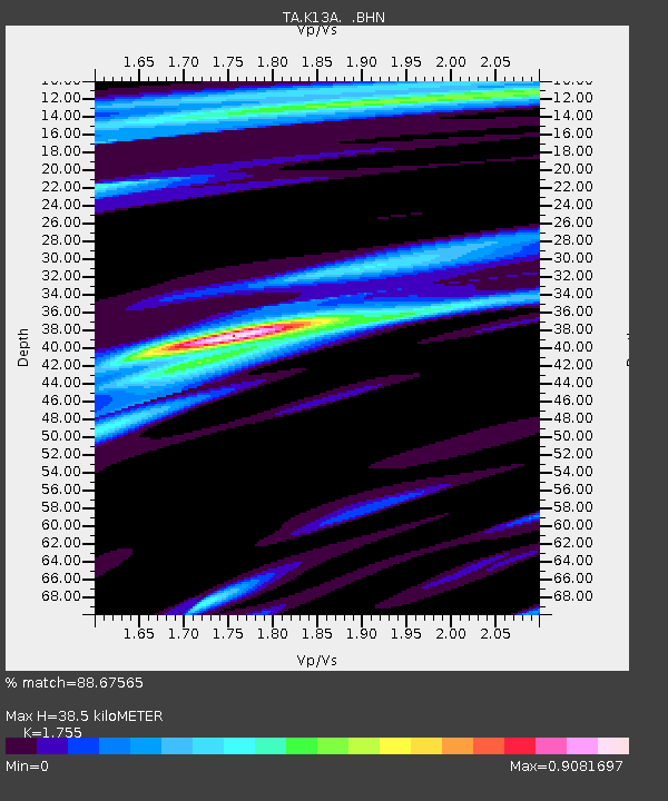
| Estimated Moho Depth: |
38.5 km |
| Estimated Crust Vp/Vs: |
1.75 |
| Assumed Crust Vp: |
6.291 km/s |
| Estimated Crust Vs: |
3.585 km/s |
| Estimated Crust Poisson's Ratio: |
0.26 |
|
| Radial Match: |
88.67565 % |
| Radial Bump: |
389 |
| Transverse Match: |
65.53529 % |
| Transverse Bump: |
400 |
| SOD ConfigId: |
2504 |
| Insert Time: |
2010-03-07 06:01:54.770 +0000 |
| GWidth: |
2.5 |
| Max Bumps: |
400 |
| Tol: |
0.001 |
|
Signal To Noise
| Channel | StoN | STA | LTA |
| TA:K13A: :BHN:20080415T23:07:26.899011Z | 7.2525907 | 9.054809E-7 | 1.2484931E-7 |
| TA:K13A: :BHE:20080415T23:07:26.899011Z | 1.3509032 | 1.4045422E-7 | 1.03970606E-7 |
| TA:K13A: :BHZ:20080415T23:07:26.899011Z | 3.5967722 | 5.977168E-7 | 1.6618144E-7 |
| Arrivals |
| Ps | 4.9 SECOND |
| PpPs | 16 SECOND |
| PsPs/PpSs | 21 SECOND |


