You are here: Home > Network List > NN - Western Great Basin/Eastern Sierra Nevada Stations List
> Station RYN Ryan, Nevada w84,gps > Earthquake Result Viewer
RYN Ryan, Nevada w84,gps - Earthquake Result Viewer
| Earthquake location: |
Off Coast Of Chiapas, Mexico |
| Earthquake latitude/longitude: |
14.0/-93.1 |
| Earthquake time(UTC): |
2019/11/20 (324) 04:27:07 GMT |
| Earthquake Depth: |
26 km |
| Earthquake Magnitude: |
6.3 Mww |
| Earthquake Catalog/Contributor: |
NEIC PDE/us |
|
| Network: |
NN Western Great Basin/Eastern Sierra Nevada |
| Station: |
RYN Ryan, Nevada w84,gps |
| Lat/Lon: |
38.63 N/118.52 W |
| Elevation: |
1651 m |
|
| Distance: |
33.3 deg |
| Az: |
322.281 deg |
| Baz: |
130.682 deg |
| Ray Param: |
0.078244336 |
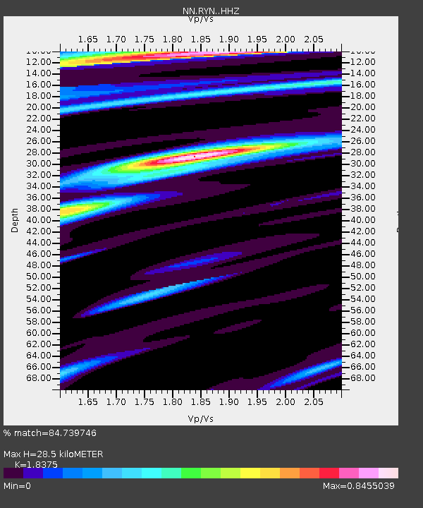
| Estimated Moho Depth: |
28.5 km |
| Estimated Crust Vp/Vs: |
1.84 |
| Assumed Crust Vp: |
6.279 km/s |
| Estimated Crust Vs: |
3.417 km/s |
| Estimated Crust Poisson's Ratio: |
0.29 |
|
| Radial Match: |
84.739746 % |
| Radial Bump: |
348 |
| Transverse Match: |
73.60195 % |
| Transverse Bump: |
377 |
| SOD ConfigId: |
19951751 |
| Insert Time: |
2019-12-04 04:47:51.962 +0000 |
| GWidth: |
2.5 |
| Max Bumps: |
400 |
| Tol: |
0.001 |
|

Signal To Noise
| Channel | StoN | STA | LTA |
| NN:RYN: :HHZ:20191120T04:33:12.424987Z | 32.88078 | 3.7664975E-6 | 1.14550126E-7 |
| NN:RYN: :HHN:20191120T04:33:12.424987Z | 5.7524915 | 1.2339872E-6 | 2.1451352E-7 |
| NN:RYN: :HHE:20191120T04:33:12.424987Z | 10.423781 | 1.796776E-6 | 1.7237276E-7 |
| Arrivals |
| Ps | 4.1 SECOND |
| PpPs | 12 SECOND |
| PsPs/PpSs | 16 SECOND |


