You are here: Home > Network List > TA - USArray Transportable Network (new EarthScope stations) Stations List
> Station B18K Kokolik River, AK, USA > Earthquake Result Viewer
B18K Kokolik River, AK, USA - Earthquake Result Viewer
| Earthquake location: |
Off Coast Of Chiapas, Mexico |
| Earthquake latitude/longitude: |
14.0/-93.1 |
| Earthquake time(UTC): |
2019/11/20 (324) 04:27:07 GMT |
| Earthquake Depth: |
26 km |
| Earthquake Magnitude: |
6.3 Mww |
| Earthquake Catalog/Contributor: |
NEIC PDE/us |
|
| Network: |
TA USArray Transportable Network (new EarthScope stations) |
| Station: |
B18K Kokolik River, AK, USA |
| Lat/Lon: |
69.36 N/161.80 W |
| Elevation: |
222 m |
|
| Distance: |
69.6 deg |
| Az: |
339.366 deg |
| Baz: |
105.186 deg |
| Ray Param: |
0.055534188 |
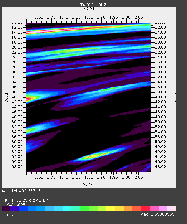
| Estimated Moho Depth: |
13.25 km |
| Estimated Crust Vp/Vs: |
1.68 |
| Assumed Crust Vp: |
5.906 km/s |
| Estimated Crust Vs: |
3.511 km/s |
| Estimated Crust Poisson's Ratio: |
0.23 |
|
| Radial Match: |
82.66716 % |
| Radial Bump: |
400 |
| Transverse Match: |
83.082726 % |
| Transverse Bump: |
400 |
| SOD ConfigId: |
19951751 |
| Insert Time: |
2019-12-04 04:48:47.116 +0000 |
| GWidth: |
2.5 |
| Max Bumps: |
400 |
| Tol: |
0.001 |
|
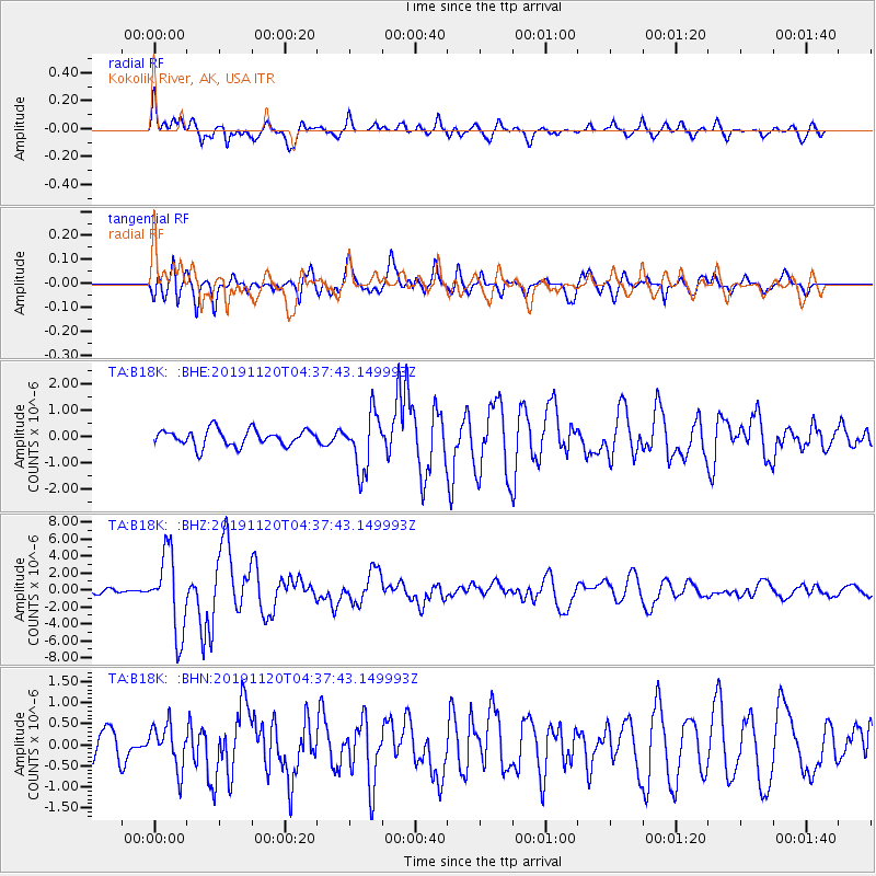
Signal To Noise
| Channel | StoN | STA | LTA |
| TA:B18K: :BHZ:20191120T04:37:43.149993Z | 11.715377 | 4.6334376E-6 | 3.9550054E-7 |
| TA:B18K: :BHN:20191120T04:37:43.149993Z | 1.4677162 | 5.190592E-7 | 3.536509E-7 |
| TA:B18K: :BHE:20191120T04:37:43.149993Z | 3.4732544 | 1.074619E-6 | 3.093983E-7 |
| Arrivals |
| Ps | 1.6 SECOND |
| PpPs | 5.8 SECOND |
| PsPs/PpSs | 7.4 SECOND |


