You are here: Home > Network List > TA - USArray Transportable Network (new EarthScope stations) Stations List
> Station C18K Utukok River, AK, USA > Earthquake Result Viewer
C18K Utukok River, AK, USA - Earthquake Result Viewer
| Earthquake location: |
Off Coast Of Chiapas, Mexico |
| Earthquake latitude/longitude: |
14.0/-93.1 |
| Earthquake time(UTC): |
2019/11/20 (324) 04:27:07 GMT |
| Earthquake Depth: |
26 km |
| Earthquake Magnitude: |
6.3 Mww |
| Earthquake Catalog/Contributor: |
NEIC PDE/us |
|
| Network: |
TA USArray Transportable Network (new EarthScope stations) |
| Station: |
C18K Utukok River, AK, USA |
| Lat/Lon: |
68.65 N/161.19 W |
| Elevation: |
845 m |
|
| Distance: |
69.2 deg |
| Az: |
338.687 deg |
| Baz: |
105.513 deg |
| Ray Param: |
0.05580036 |
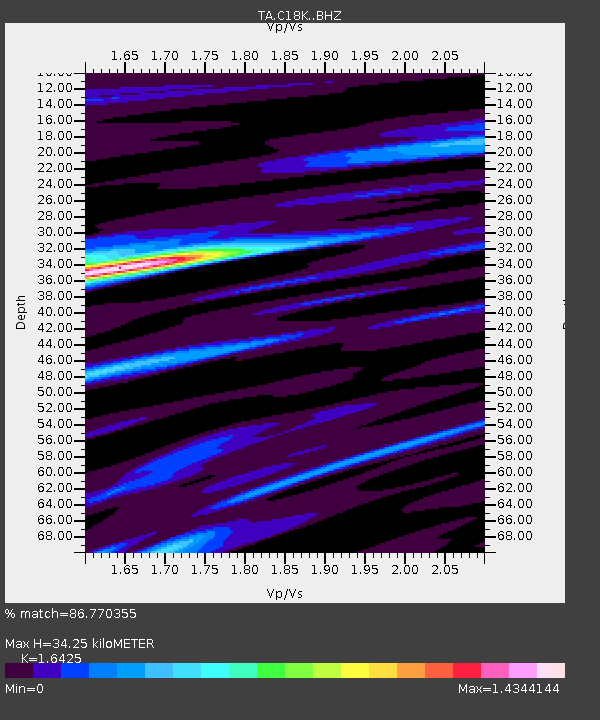
| Estimated Moho Depth: |
34.25 km |
| Estimated Crust Vp/Vs: |
1.64 |
| Assumed Crust Vp: |
5.906 km/s |
| Estimated Crust Vs: |
3.596 km/s |
| Estimated Crust Poisson's Ratio: |
0.21 |
|
| Radial Match: |
86.770355 % |
| Radial Bump: |
400 |
| Transverse Match: |
89.55885 % |
| Transverse Bump: |
400 |
| SOD ConfigId: |
19951751 |
| Insert Time: |
2019-12-04 04:48:52.423 +0000 |
| GWidth: |
2.5 |
| Max Bumps: |
400 |
| Tol: |
0.001 |
|

Signal To Noise
| Channel | StoN | STA | LTA |
| TA:C18K: :BHZ:20191120T04:37:40.675017Z | 11.067273 | 2.8345996E-6 | 2.5612448E-7 |
| TA:C18K: :BHN:20191120T04:37:40.675017Z | 3.164168 | 8.836894E-7 | 2.792802E-7 |
| TA:C18K: :BHE:20191120T04:37:40.675017Z | 3.6855009 | 1.1402622E-6 | 3.0939137E-7 |
| Arrivals |
| Ps | 3.9 SECOND |
| PpPs | 15 SECOND |
| PsPs/PpSs | 19 SECOND |


