You are here: Home > Network List > TA - USArray Transportable Network (new EarthScope stations) Stations List
> Station K13A Stover Farm, Hazelton, ID, USA > Earthquake Result Viewer
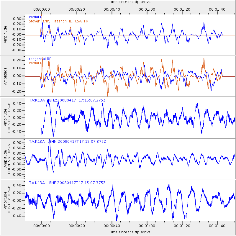
K13A Stover Farm, Hazelton, ID, USA - Earthquake Result Viewer
*The percent match for this event was below the threshold and hence no stack was calculated.
| Earthquake location: |
Mariana Islands Region |
| Earthquake latitude/longitude: |
15.9/144.9 |
| Earthquake time(UTC): |
2008/04/17 (108) 17:02:52 GMT |
| Earthquake Depth: |
10 km |
| Earthquake Magnitude: |
5.5 MB, 5.2 MS, 5.5 MW, 5.5 MW |
| Earthquake Catalog/Contributor: |
WHDF/NEIC |
|
| Network: |
TA USArray Transportable Network (new EarthScope stations) |
| Station: |
K13A Stover Farm, Hazelton, ID, USA |
| Lat/Lon: |
42.65 N/114.08 W |
| Elevation: |
1222 m |
|
| Distance: |
87.3 deg |
| Az: |
46.465 deg |
| Baz: |
288.991 deg |
| Ray Param: |
$rayparam |
*The percent match for this event was below the threshold and hence was not used in the summary stack. |
|
| Radial Match: |
68.49605 % |
| Radial Bump: |
400 |
| Transverse Match: |
38.150623 % |
| Transverse Bump: |
400 |
| SOD ConfigId: |
2504 |
| Insert Time: |
2010-03-07 06:02:18.032 +0000 |
| GWidth: |
2.5 |
| Max Bumps: |
400 |
| Tol: |
0.001 |
|
Signal To Noise
| Channel | StoN | STA | LTA |
| TA:K13A: :BHN:20080417T17:15:07.375Z | 2.7462978 | 4.3657064E-7 | 1.5896697E-7 |
| TA:K13A: :BHE:20080417T17:15:07.375Z | 0.6472745 | 1.1205787E-7 | 1.7312263E-7 |
| TA:K13A: :BHZ:20080417T17:15:07.375Z | 0.86835897 | 2.0134502E-7 | 2.3186841E-7 |
| Arrivals |
| Ps | |
| PpPs | |
| PsPs/PpSs | |


