You are here: Home > Network List > TA - USArray Transportable Network (new EarthScope stations) Stations List
> Station E17K Hotham Inlet, AK, USA > Earthquake Result Viewer
E17K Hotham Inlet, AK, USA - Earthquake Result Viewer
| Earthquake location: |
Off Coast Of Chiapas, Mexico |
| Earthquake latitude/longitude: |
14.0/-93.1 |
| Earthquake time(UTC): |
2019/11/20 (324) 04:27:07 GMT |
| Earthquake Depth: |
26 km |
| Earthquake Magnitude: |
6.3 Mww |
| Earthquake Catalog/Contributor: |
NEIC PDE/us |
|
| Network: |
TA USArray Transportable Network (new EarthScope stations) |
| Station: |
E17K Hotham Inlet, AK, USA |
| Lat/Lon: |
67.08 N/161.83 W |
| Elevation: |
233 m |
|
| Distance: |
69.0 deg |
| Az: |
336.993 deg |
| Baz: |
104.322 deg |
| Ray Param: |
0.05591403 |
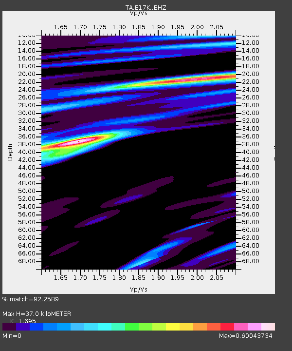
| Estimated Moho Depth: |
37.0 km |
| Estimated Crust Vp/Vs: |
1.70 |
| Assumed Crust Vp: |
6.276 km/s |
| Estimated Crust Vs: |
3.703 km/s |
| Estimated Crust Poisson's Ratio: |
0.23 |
|
| Radial Match: |
92.2589 % |
| Radial Bump: |
343 |
| Transverse Match: |
68.81167 % |
| Transverse Bump: |
400 |
| SOD ConfigId: |
19951751 |
| Insert Time: |
2019-12-04 04:49:03.138 +0000 |
| GWidth: |
2.5 |
| Max Bumps: |
400 |
| Tol: |
0.001 |
|

Signal To Noise
| Channel | StoN | STA | LTA |
| TA:E17K: :BHZ:20191120T04:37:39.600005Z | 18.939817 | 3.8855956E-6 | 2.0515488E-7 |
| TA:E17K: :BHN:20191120T04:37:39.600005Z | 2.5135248 | 5.422518E-7 | 2.1573364E-7 |
| TA:E17K: :BHE:20191120T04:37:39.600005Z | 7.011644 | 1.355782E-6 | 1.933615E-7 |
| Arrivals |
| Ps | 4.3 SECOND |
| PpPs | 15 SECOND |
| PsPs/PpSs | 20 SECOND |


