You are here: Home > Network List > TA - USArray Transportable Network (new EarthScope stations) Stations List
> Station E23K Chandalar, AK, USA > Earthquake Result Viewer
E23K Chandalar, AK, USA - Earthquake Result Viewer
| Earthquake location: |
Off Coast Of Chiapas, Mexico |
| Earthquake latitude/longitude: |
14.0/-93.1 |
| Earthquake time(UTC): |
2019/11/20 (324) 04:27:07 GMT |
| Earthquake Depth: |
26 km |
| Earthquake Magnitude: |
6.3 Mww |
| Earthquake Catalog/Contributor: |
NEIC PDE/us |
|
| Network: |
TA USArray Transportable Network (new EarthScope stations) |
| Station: |
E23K Chandalar, AK, USA |
| Lat/Lon: |
68.06 N/149.62 W |
| Elevation: |
1084 m |
|
| Distance: |
64.9 deg |
| Az: |
339.766 deg |
| Baz: |
116.691 deg |
| Ray Param: |
0.05856211 |
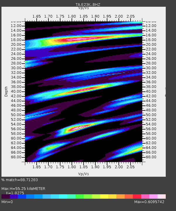
| Estimated Moho Depth: |
55.25 km |
| Estimated Crust Vp/Vs: |
1.83 |
| Assumed Crust Vp: |
6.316 km/s |
| Estimated Crust Vs: |
3.456 km/s |
| Estimated Crust Poisson's Ratio: |
0.29 |
|
| Radial Match: |
88.71283 % |
| Radial Bump: |
400 |
| Transverse Match: |
86.38962 % |
| Transverse Bump: |
400 |
| SOD ConfigId: |
19951751 |
| Insert Time: |
2019-12-04 04:49:06.498 +0000 |
| GWidth: |
2.5 |
| Max Bumps: |
400 |
| Tol: |
0.001 |
|

Signal To Noise
| Channel | StoN | STA | LTA |
| TA:E23K: :BHZ:20191120T04:37:13.975005Z | 20.448734 | 4.9850964E-6 | 2.4378508E-7 |
| TA:E23K: :BHN:20191120T04:37:13.975005Z | 4.506284 | 5.85507E-7 | 1.2993121E-7 |
| TA:E23K: :BHE:20191120T04:37:13.975005Z | 5.5609975 | 1.5275575E-6 | 2.746913E-7 |
| Arrivals |
| Ps | 7.5 SECOND |
| PpPs | 24 SECOND |
| PsPs/PpSs | 31 SECOND |


