You are here: Home > Network List > IU - Global Seismograph Network (GSN - IRIS/USGS) Stations List
> Station PMG Port Moresby, New Guinea > Earthquake Result Viewer
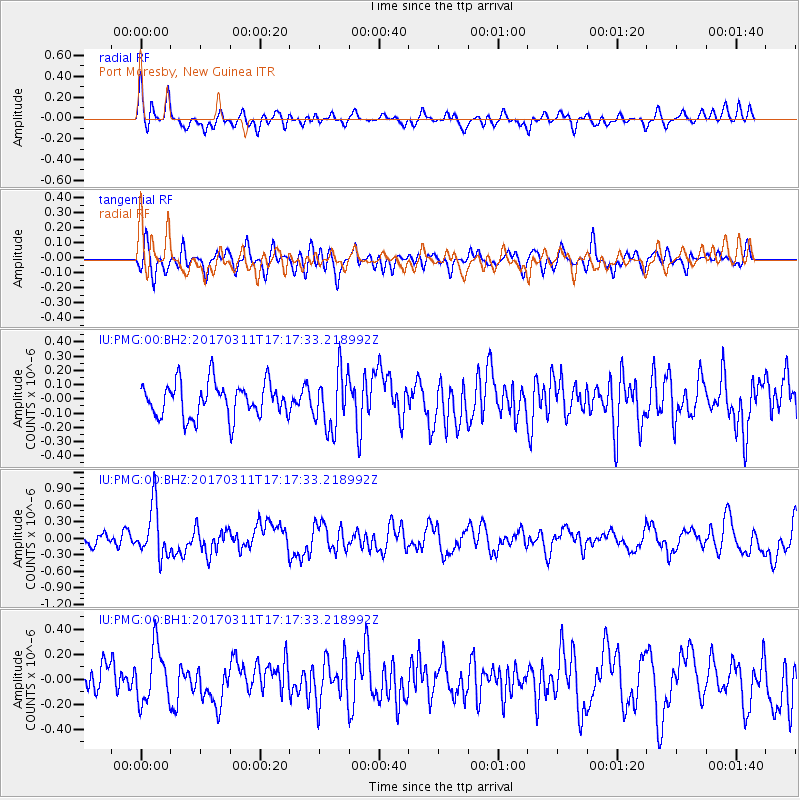
PMG Port Moresby, New Guinea - Earthquake Result Viewer
*The percent match for this event was below the threshold and hence no stack was calculated.
| Earthquake location: |
Kermadec Islands, New Zealand |
| Earthquake latitude/longitude: |
-30.6/-177.5 |
| Earthquake time(UTC): |
2017/03/11 (070) 17:10:38 GMT |
| Earthquake Depth: |
19 km |
| Earthquake Magnitude: |
5.5 mb |
| Earthquake Catalog/Contributor: |
NEIC PDE/us |
|
| Network: |
IU Global Seismograph Network (GSN - IRIS/USGS) |
| Station: |
PMG Port Moresby, New Guinea |
| Lat/Lon: |
9.40 S/147.16 E |
| Elevation: |
90 m |
|
| Distance: |
39.1 deg |
| Az: |
295.204 deg |
| Baz: |
127.79 deg |
| Ray Param: |
$rayparam |
*The percent match for this event was below the threshold and hence was not used in the summary stack. |
|
| Radial Match: |
65.94776 % |
| Radial Bump: |
400 |
| Transverse Match: |
66.92604 % |
| Transverse Bump: |
400 |
| SOD ConfigId: |
1992691 |
| Insert Time: |
2017-03-25 17:12:24.923 +0000 |
| GWidth: |
2.5 |
| Max Bumps: |
400 |
| Tol: |
0.001 |
|
Signal To Noise
| Channel | StoN | STA | LTA |
| IU:PMG:00:BHZ:20170311T17:17:33.218992Z | 3.5850751 | 4.628039E-7 | 1.2909183E-7 |
| IU:PMG:00:BH1:20170311T17:17:33.218992Z | 2.0774686 | 2.2289923E-7 | 1.07293666E-7 |
| IU:PMG:00:BH2:20170311T17:17:33.218992Z | 1.6385959 | 1.9783256E-7 | 1.2073298E-7 |
| Arrivals |
| Ps | |
| PpPs | |
| PsPs/PpSs | |


