You are here: Home > Network List > TS - TERRAscope (Southern California Seismic Network) Stations List
> Station PAS Pasadena, California, USA > Earthquake Result Viewer
PAS Pasadena, California, USA - Earthquake Result Viewer
| Earthquake location: |
Near Coast Of Central Chile |
| Earthquake latitude/longitude: |
-31.4/-71.9 |
| Earthquake time(UTC): |
1992/11/28 (333) 03:13:37 GMT |
| Earthquake Depth: |
39 km |
| Earthquake Magnitude: |
5.9 MB, 6.4 MS, 6.0 MD |
| Earthquake Catalog/Contributor: |
WHDF/NEIC |
|
| Network: |
TS TERRAscope (Southern California Seismic Network) |
| Station: |
PAS Pasadena, California, USA |
| Lat/Lon: |
34.15 N/118.17 W |
| Elevation: |
295 m |
|
| Distance: |
78.4 deg |
| Az: |
322.314 deg |
| Baz: |
140.924 deg |
| Ray Param: |
0.049602203 |
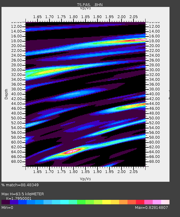
| Estimated Moho Depth: |
63.5 km |
| Estimated Crust Vp/Vs: |
1.80 |
| Assumed Crust Vp: |
6.1 km/s |
| Estimated Crust Vs: |
3.398 km/s |
| Estimated Crust Poisson's Ratio: |
0.27 |
|
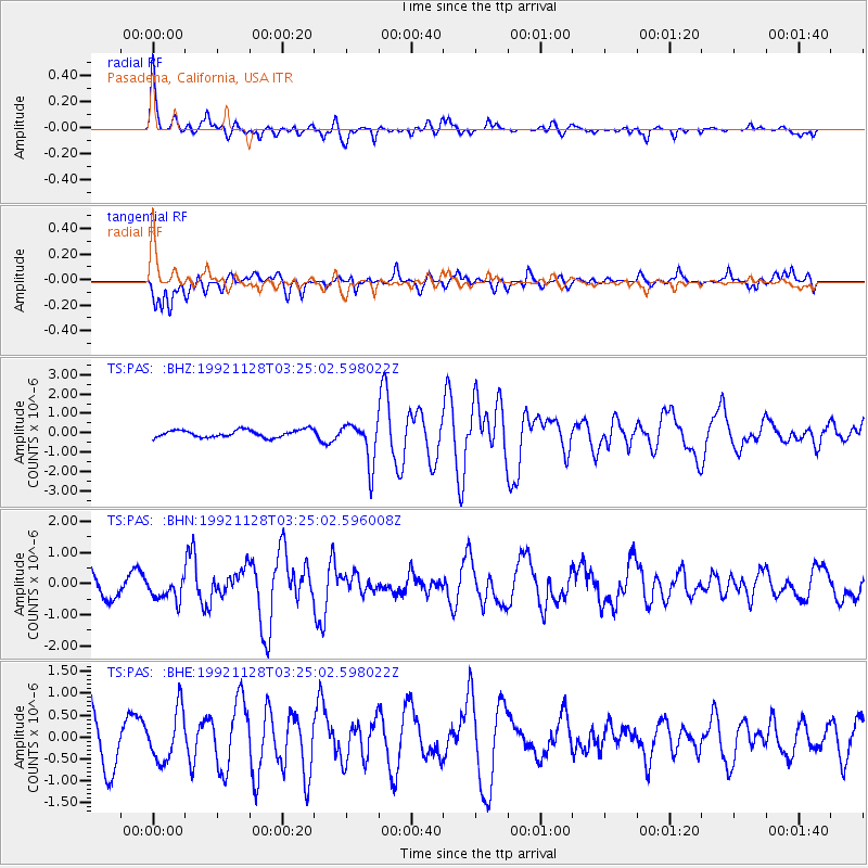
| Radial Match: |
88.48349 % |
| Radial Bump: |
390 |
| Transverse Match: |
55.112526 % |
| Transverse Bump: |
400 |
| SOD ConfigId: |
16938 |
| Insert Time: |
2010-02-26 14:35:03.168 +0000 |
| GWidth: |
2.5 |
| Max Bumps: |
400 |
| Tol: |
0.001 |
|
Signal To Noise
| Channel | StoN | STA | LTA |
| TS:PAS: :BHN:19921128T03:25:02.596008Z | 0.976241 | 3.5445743E-7 | 3.6308396E-7 |
| TS:PAS: :BHE:19921128T03:25:02.598022Z | 1.0736725 | 5.731639E-7 | 5.338349E-7 |
| TS:PAS: :BHZ:19921128T03:25:02.598022Z | 5.7282543 | 1.093913E-6 | 1.9096795E-7 |
| Arrivals |
| Ps | 8.5 SECOND |
| PpPs | 28 SECOND |
| PsPs/PpSs | 37 SECOND |


