You are here: Home > Network List > TS - TERRAscope (Southern California Seismic Network) Stations List
> Station PAS Pasadena, California, USA > Earthquake Result Viewer
PAS Pasadena, California, USA - Earthquake Result Viewer
| Earthquake location: |
South Of Panama |
| Earthquake latitude/longitude: |
6.1/-82.4 |
| Earthquake time(UTC): |
1992/06/26 (178) 11:32:30 GMT |
| Earthquake Depth: |
33 km |
| Earthquake Magnitude: |
5.8 MB, 5.4 MS |
| Earthquake Catalog/Contributor: |
WHDF/NEIC |
|
| Network: |
TS TERRAscope (Southern California Seismic Network) |
| Station: |
PAS Pasadena, California, USA |
| Lat/Lon: |
34.15 N/118.17 W |
| Elevation: |
295 m |
|
| Distance: |
43.3 deg |
| Az: |
314.947 deg |
| Baz: |
121.941 deg |
| Ray Param: |
0.07258962 |
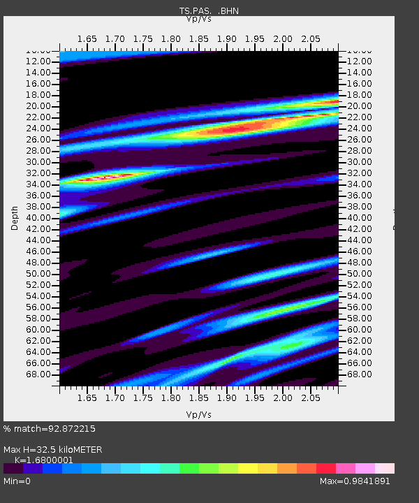
| Estimated Moho Depth: |
32.5 km |
| Estimated Crust Vp/Vs: |
1.68 |
| Assumed Crust Vp: |
6.1 km/s |
| Estimated Crust Vs: |
3.631 km/s |
| Estimated Crust Poisson's Ratio: |
0.23 |
|
| Radial Match: |
92.872215 % |
| Radial Bump: |
233 |
| Transverse Match: |
80.99251 % |
| Transverse Bump: |
337 |
| SOD ConfigId: |
17000 |
| Insert Time: |
2010-02-26 14:35:04.334 +0000 |
| GWidth: |
2.5 |
| Max Bumps: |
400 |
| Tol: |
0.001 |
|
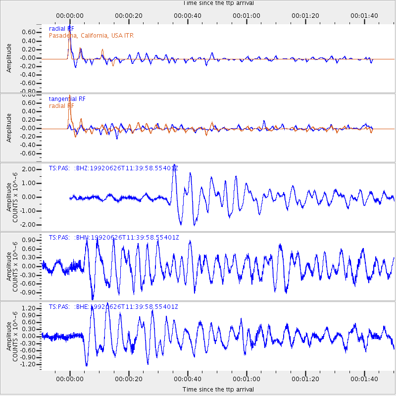
Signal To Noise
| Channel | StoN | STA | LTA |
| TS:PAS: :BHN:19920626T11:39:58.55401Z | 1.0159515 | 1.1965349E-7 | 1.1777481E-7 |
| TS:PAS: :BHE:19920626T11:39:58.55401Z | 1.3377719 | 1.1181832E-7 | 8.35855E-8 |
| TS:PAS: :BHZ:19920626T11:39:58.55401Z | 2.5014682 | 2.7397033E-7 | 1.0952381E-7 |
| Arrivals |
| Ps | 3.9 SECOND |
| PpPs | 13 SECOND |
| PsPs/PpSs | 17 SECOND |


