You are here: Home > Network List > TA - USArray Transportable Network (new EarthScope stations) Stations List
> Station R33M Jennings River, BC, CAN > Earthquake Result Viewer
R33M Jennings River, BC, CAN - Earthquake Result Viewer
| Earthquake location: |
Off Coast Of Chiapas, Mexico |
| Earthquake latitude/longitude: |
14.0/-93.1 |
| Earthquake time(UTC): |
2019/11/20 (324) 04:27:07 GMT |
| Earthquake Depth: |
26 km |
| Earthquake Magnitude: |
6.3 Mww |
| Earthquake Catalog/Contributor: |
NEIC PDE/us |
|
| Network: |
TA USArray Transportable Network (new EarthScope stations) |
| Station: |
R33M Jennings River, BC, CAN |
| Lat/Lon: |
59.39 N/130.97 W |
| Elevation: |
1437 m |
|
| Distance: |
53.3 deg |
| Az: |
336.948 deg |
| Baz: |
132.013 deg |
| Ray Param: |
0.066179 |
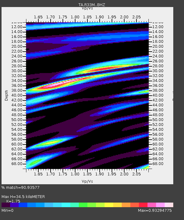
| Estimated Moho Depth: |
34.5 km |
| Estimated Crust Vp/Vs: |
1.75 |
| Assumed Crust Vp: |
6.597 km/s |
| Estimated Crust Vs: |
3.77 km/s |
| Estimated Crust Poisson's Ratio: |
0.26 |
|
| Radial Match: |
90.93577 % |
| Radial Bump: |
400 |
| Transverse Match: |
82.544136 % |
| Transverse Bump: |
400 |
| SOD ConfigId: |
19951751 |
| Insert Time: |
2019-12-04 04:50:10.063 +0000 |
| GWidth: |
2.5 |
| Max Bumps: |
400 |
| Tol: |
0.001 |
|
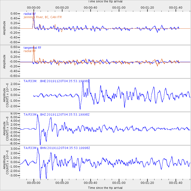
Signal To Noise
| Channel | StoN | STA | LTA |
| TA:R33M: :BHZ:20191120T04:35:53.19998Z | 14.181006 | 3.8531575E-6 | 2.7171257E-7 |
| TA:R33M: :BHN:20191120T04:35:53.19998Z | 5.561366 | 1.6743198E-6 | 3.010627E-7 |
| TA:R33M: :BHE:20191120T04:35:53.19998Z | 7.949726 | 1.1725832E-6 | 1.4749983E-7 |
| Arrivals |
| Ps | 4.2 SECOND |
| PpPs | 14 SECOND |
| PsPs/PpSs | 18 SECOND |


