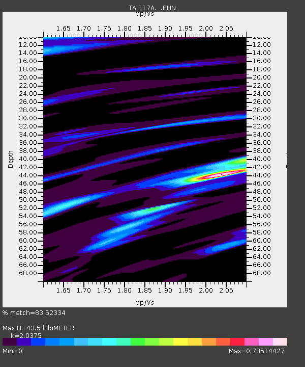
117A Oracle, AZ, USA - Earthquake Result Viewer
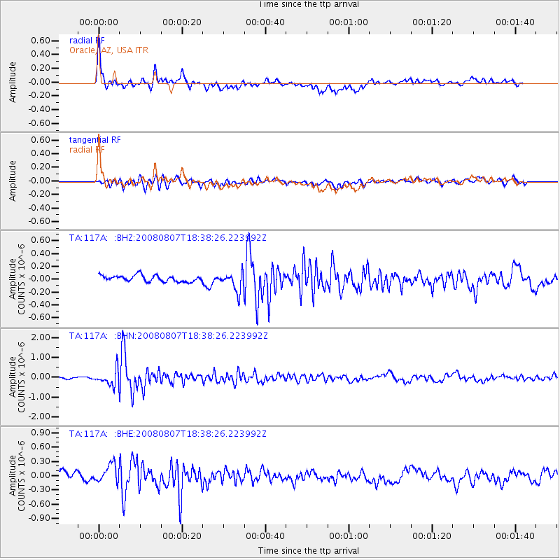
Earthquake location: Andreanof Islands, Aleutian Is.
Earthquake latitude/longitude: 52.2/-175.7
Earthquake time(UTC): 2008/08/07 (220) 18:30:03 GMT
Earthquake Depth: 12 km
Earthquake Magnitude: 5.6 MB, 5.5 MS, 5.8 MW, 5.8 MW
Earthquake Catalog/Contributor: WHDF/NEIC
Network: TA USArray Transportable Network (new EarthScope stations)
Station: 117A Oracle, AZ, USA
Lat/Lon: 32.57 N/110.74 W
Elevation: 1544 m
Distance: 50.0 deg
Az: 86.43 deg
Baz: 313.308 deg
Ray Param: 0.06833049
Estimated Moho Depth: 43.5 km
Estimated Crust Vp/Vs: 2.04
Assumed Crust Vp: 6.276 km/s
Estimated Crust Vs: 3.08 km/s
Estimated Crust Poisson's Ratio: 0.34
Radial Match: 83.52334 %
Radial Bump: 400
Transverse Match: 74.22531 %
Transverse Bump: 400
SOD ConfigId: 2504
Insert Time: 2010-03-07 06:03:00.203 +0000
GWidth: 2.5
Max Bumps: 400
Tol: 0.001

Signal To Noise

ChannelStoNSTALTA
TA:117A: :BHN:20080807T18:38:26.223992Z8.3991554.0056784E-74.7691447E-8
TA:117A: :BHE:20080807T18:38:26.223992Z2.54289482.148114E-78.447514E-8
TA:117A: :BHZ:20080807T18:38:26.223992Z3.23494821.5585621E-74.8178894E-8
Arrivals
Ps7.5 SECOND
PpPs20 SECOND
PsPs/PpSs28 SECOND