You are here: Home > Network List > TS - TERRAscope (Southern California Seismic Network) Stations List
> Station PAS Pasadena, California, USA > Earthquake Result Viewer
PAS Pasadena, California, USA - Earthquake Result Viewer
| Earthquake location: |
Fiji Islands Region |
| Earthquake latitude/longitude: |
-17.7/-178.8 |
| Earthquake time(UTC): |
1992/08/30 (243) 20:09:06 GMT |
| Earthquake Depth: |
573 km |
| Earthquake Magnitude: |
5.8 MB |
| Earthquake Catalog/Contributor: |
WHDF/NEIC |
|
| Network: |
TS TERRAscope (Southern California Seismic Network) |
| Station: |
PAS Pasadena, California, USA |
| Lat/Lon: |
34.15 N/118.17 W |
| Elevation: |
295 m |
|
| Distance: |
77.4 deg |
| Az: |
47.773 deg |
| Baz: |
238.315 deg |
| Ray Param: |
0.048570048 |
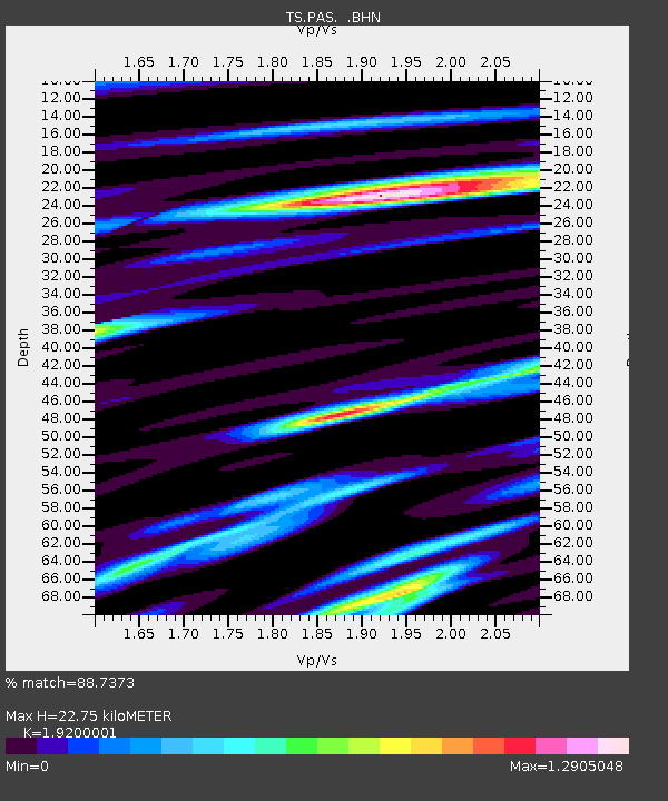
| Estimated Moho Depth: |
22.75 km |
| Estimated Crust Vp/Vs: |
1.92 |
| Assumed Crust Vp: |
6.1 km/s |
| Estimated Crust Vs: |
3.177 km/s |
| Estimated Crust Poisson's Ratio: |
0.31 |
|
| Radial Match: |
88.7373 % |
| Radial Bump: |
400 |
| Transverse Match: |
73.39347 % |
| Transverse Bump: |
400 |
| SOD ConfigId: |
17000 |
| Insert Time: |
2010-02-26 14:35:07.948 +0000 |
| GWidth: |
2.5 |
| Max Bumps: |
400 |
| Tol: |
0.001 |
|

Signal To Noise
| Channel | StoN | STA | LTA |
| TS:PAS: :BHN:19920830T20:19:32.18302Z | 3.7577567 | 3.558287E-7 | 9.469178E-8 |
| TS:PAS: :BHE:19920830T20:19:32.18302Z | 4.5819387 | 4.4791977E-7 | 9.775769E-8 |
| TS:PAS: :BHZ:19920830T20:19:32.18302Z | 20.508635 | 1.8098339E-6 | 8.8247404E-8 |
| Arrivals |
| Ps | 3.5 SECOND |
| PpPs | 11 SECOND |
| PsPs/PpSs | 14 SECOND |


