You are here: Home > Network List > WY - Yellowstone Wyoming Seismic Network Stations List
> Station YDD Grant Village, YNP, WY, USA old TA-H17A > Earthquake Result Viewer
YDD Grant Village, YNP, WY, USA old TA-H17A - Earthquake Result Viewer
| Earthquake location: |
Off Coast Of Chiapas, Mexico |
| Earthquake latitude/longitude: |
14.0/-93.1 |
| Earthquake time(UTC): |
2019/11/20 (324) 04:27:07 GMT |
| Earthquake Depth: |
26 km |
| Earthquake Magnitude: |
6.3 Mww |
| Earthquake Catalog/Contributor: |
NEIC PDE/us |
|
| Network: |
WY Yellowstone Wyoming Seismic Network |
| Station: |
YDD Grant Village, YNP, WY, USA old TA-H17A |
| Lat/Lon: |
44.40 N/110.58 W |
| Elevation: |
2400 m |
|
| Distance: |
33.8 deg |
| Az: |
337.285 deg |
| Baz: |
148.468 deg |
| Ray Param: |
0.0780088 |
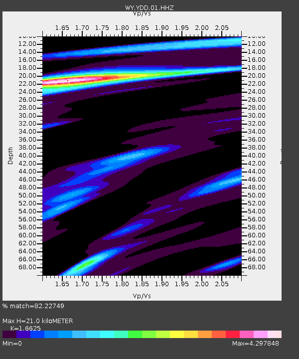
| Estimated Moho Depth: |
21.0 km |
| Estimated Crust Vp/Vs: |
1.66 |
| Assumed Crust Vp: |
6.35 km/s |
| Estimated Crust Vs: |
3.82 km/s |
| Estimated Crust Poisson's Ratio: |
0.22 |
|
| Radial Match: |
82.22749 % |
| Radial Bump: |
400 |
| Transverse Match: |
80.70459 % |
| Transverse Bump: |
400 |
| SOD ConfigId: |
19951751 |
| Insert Time: |
2019-12-04 04:52:07.068 +0000 |
| GWidth: |
2.5 |
| Max Bumps: |
400 |
| Tol: |
0.001 |
|

Signal To Noise
| Channel | StoN | STA | LTA |
| WY:YDD:01:HHZ:20191120T04:33:16.869994Z | 17.499249 | 7.405617E-8 | 4.231963E-9 |
| WY:YDD:01:HHN:20191120T04:33:16.869994Z | 14.7922535 | 5.8692162E-8 | 3.9677635E-9 |
| WY:YDD:01:HHE:20191120T04:33:16.869994Z | 7.802674 | 3.9304126E-8 | 5.037264E-9 |
| Arrivals |
| Ps | 2.4 SECOND |
| PpPs | 8.1 SECOND |
| PsPs/PpSs | 10 SECOND |


