You are here: Home > Network List > TA - USArray Transportable Network (new EarthScope stations) Stations List
> Station 117A Oracle, AZ, USA > Earthquake Result Viewer
117A Oracle, AZ, USA - Earthquake Result Viewer
| Earthquake location: |
Kermadec Islands, New Zealand |
| Earthquake latitude/longitude: |
-30.0/-177.9 |
| Earthquake time(UTC): |
2007/11/20 (324) 15:28:28 GMT |
| Earthquake Depth: |
59 km |
| Earthquake Magnitude: |
6.0 MB, 5.9 MW, 5.8 MW |
| Earthquake Catalog/Contributor: |
WHDF/NEIC |
|
| Network: |
TA USArray Transportable Network (new EarthScope stations) |
| Station: |
117A Oracle, AZ, USA |
| Lat/Lon: |
32.57 N/110.74 W |
| Elevation: |
1544 m |
|
| Distance: |
89.0 deg |
| Az: |
51.117 deg |
| Baz: |
233.08 deg |
| Ray Param: |
0.042051524 |
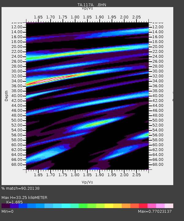
| Estimated Moho Depth: |
33.25 km |
| Estimated Crust Vp/Vs: |
1.70 |
| Assumed Crust Vp: |
6.276 km/s |
| Estimated Crust Vs: |
3.703 km/s |
| Estimated Crust Poisson's Ratio: |
0.23 |
|
| Radial Match: |
90.20138 % |
| Radial Bump: |
328 |
| Transverse Match: |
83.79316 % |
| Transverse Bump: |
400 |
| SOD ConfigId: |
2564 |
| Insert Time: |
2010-03-07 06:03:25.520 +0000 |
| GWidth: |
2.5 |
| Max Bumps: |
400 |
| Tol: |
0.001 |
|
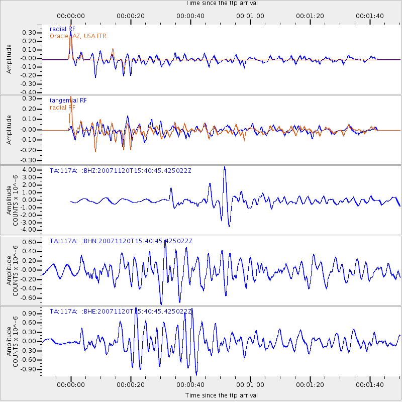
Signal To Noise
| Channel | StoN | STA | LTA |
| TA:117A: :BHN:20071120T15:40:45.425022Z | 1.598706 | 1.4209215E-7 | 8.887947E-8 |
| TA:117A: :BHE:20071120T15:40:45.425022Z | 1.3602115 | 1.5403275E-7 | 1.1324176E-7 |
| TA:117A: :BHZ:20071120T15:40:45.425022Z | 2.7449598 | 6.127771E-7 | 2.2323718E-7 |
| Arrivals |
| Ps | 3.8 SECOND |
| PpPs | 14 SECOND |
| PsPs/PpSs | 18 SECOND |


