You are here: Home > Network List > AG - Arkansas Seismic Network Stations List
> Station U40A Yellville, AR > Earthquake Result Viewer
U40A Yellville, AR - Earthquake Result Viewer

| Earthquake location: |
Sea Of Okhotsk |
| Earthquake latitude/longitude: |
53.2/153.7 |
| Earthquake time(UTC): |
2019/11/20 (324) 08:26:07 GMT |
| Earthquake Depth: |
487 km |
| Earthquake Magnitude: |
6.3 Mww |
| Earthquake Catalog/Contributor: |
NEIC PDE/us |
|
| Network: |
AG Arkansas Seismic Network |
| Station: |
U40A Yellville, AR |
| Lat/Lon: |
36.36 N/92.85 W |
| Elevation: |
374 m |
|
| Distance: |
73.9 deg |
| Az: |
50.428 deg |
| Baz: |
324.903 deg |
| Ray Param: |
0.051184494 |
| Estimated Moho Depth: |
26.25 km |
| Estimated Crust Vp/Vs: |
1.71 |
| Assumed Crust Vp: |
6.53 km/s |
| Estimated Crust Vs: |
3.825 km/s |
| Estimated Crust Poisson's Ratio: |
0.24 |
|
| Radial Match: |
84.09213 % |
| Radial Bump: |
244 |
| Transverse Match: |
69.61825 % |
| Transverse Bump: |
367 |
| SOD ConfigId: |
19951751 |
| Insert Time: |
2019-12-04 08:28:24.389 +0000 |
| GWidth: |
2.5 |
| Max Bumps: |
400 |
| Tol: |
0.001 |
|
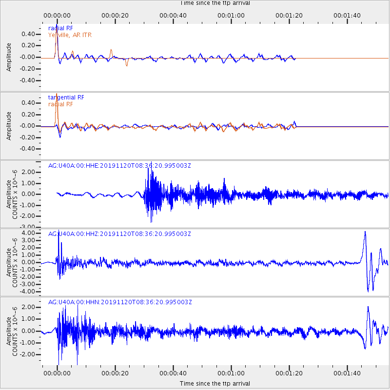
Signal To Noise
| Channel | StoN | STA | LTA |
| AG:U40A:00:HHZ:20191120T08:36:20.995003Z | 10.801505 | 1.095728E-6 | 1.0144216E-7 |
| AG:U40A:00:HHN:20191120T08:36:20.995003Z | 9.173798 | 9.1673706E-7 | 9.9929935E-8 |
| AG:U40A:00:HHE:20191120T08:36:20.995003Z | 9.918923 | 1.0697289E-6 | 1.0784728E-7 |
| Arrivals |
| Ps | 2.9 SECOND |
| PpPs | 11 SECOND |
| PsPs/PpSs | 13 SECOND |


