You are here: Home > Network List > TA - USArray Transportable Network (new EarthScope stations) Stations List
> Station 117A Oracle, AZ, USA > Earthquake Result Viewer
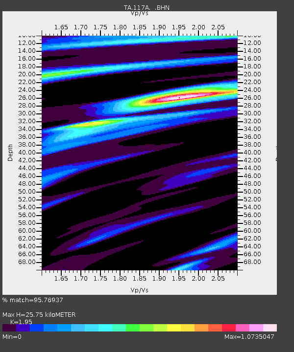
117A Oracle, AZ, USA - Earthquake Result Viewer
| Earthquake location: |
Near West Coast Of Colombia |
| Earthquake latitude/longitude: |
3.0/-78.0 |
| Earthquake time(UTC): |
2007/09/10 (253) 01:49:14 GMT |
| Earthquake Depth: |
31 km |
| Earthquake Magnitude: |
6.1 MB, 6.7 MS, 6.8 MW |
| Earthquake Catalog/Contributor: |
WHDF/NEIC |
|
| Network: |
TA USArray Transportable Network (new EarthScope stations) |
| Station: |
117A Oracle, AZ, USA |
| Lat/Lon: |
32.57 N/110.74 W |
| Elevation: |
1544 m |
|
| Distance: |
42.5 deg |
| Az: |
317.477 deg |
| Baz: |
126.927 deg |
| Ray Param: |
0.07305449 |
| Estimated Moho Depth: |
25.75 km |
| Estimated Crust Vp/Vs: |
1.95 |
| Assumed Crust Vp: |
6.276 km/s |
| Estimated Crust Vs: |
3.218 km/s |
| Estimated Crust Poisson's Ratio: |
0.32 |
|
| Radial Match: |
95.76937 % |
| Radial Bump: |
385 |
| Transverse Match: |
76.78526 % |
| Transverse Bump: |
400 |
| SOD ConfigId: |
2564 |
| Insert Time: |
2010-03-07 06:03:40.944 +0000 |
| GWidth: |
2.5 |
| Max Bumps: |
400 |
| Tol: |
0.001 |
|

Signal To Noise
| Channel | StoN | STA | LTA |
| TA:117A: :BHN:20070910T01:56:36.475005Z | 6.2984705 | 5.1315055E-7 | 8.147226E-8 |
| TA:117A: :BHE:20070910T01:56:36.475005Z | 12.608949 | 7.199814E-7 | 5.710083E-8 |
| TA:117A: :BHZ:20070910T01:56:36.475005Z | 20.240046 | 1.7608472E-6 | 8.699819E-8 |
| Arrivals |
| Ps | 4.1 SECOND |
| PpPs | 11 SECOND |
| PsPs/PpSs | 16 SECOND |


