You are here: Home > Network List > AK - Alaska Regional Network Stations List
> Station PPD Porcupine Dome, AK, USA > Earthquake Result Viewer
PPD Porcupine Dome, AK, USA - Earthquake Result Viewer
| Earthquake location: |
Sea Of Okhotsk |
| Earthquake latitude/longitude: |
53.2/153.7 |
| Earthquake time(UTC): |
2019/11/20 (324) 08:26:07 GMT |
| Earthquake Depth: |
487 km |
| Earthquake Magnitude: |
6.3 Mww |
| Earthquake Catalog/Contributor: |
NEIC PDE/us |
|
| Network: |
AK Alaska Regional Network |
| Station: |
PPD Porcupine Dome, AK, USA |
| Lat/Lon: |
65.52 N/145.52 W |
| Elevation: |
1498 m |
|
| Distance: |
32.0 deg |
| Az: |
43.377 deg |
| Baz: |
277.122 deg |
| Ray Param: |
0.07679616 |
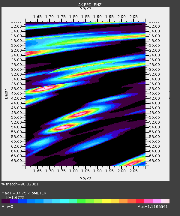
| Estimated Moho Depth: |
37.75 km |
| Estimated Crust Vp/Vs: |
1.68 |
| Assumed Crust Vp: |
6.566 km/s |
| Estimated Crust Vs: |
3.914 km/s |
| Estimated Crust Poisson's Ratio: |
0.22 |
|
| Radial Match: |
90.32361 % |
| Radial Bump: |
400 |
| Transverse Match: |
60.7322 % |
| Transverse Bump: |
400 |
| SOD ConfigId: |
19951751 |
| Insert Time: |
2019-12-04 08:28:43.811 +0000 |
| GWidth: |
2.5 |
| Max Bumps: |
400 |
| Tol: |
0.001 |
|

Signal To Noise
| Channel | StoN | STA | LTA |
| AK:PPD: :BHZ:20191120T08:31:22.168007Z | 9.281017 | 1.390854E-6 | 1.4986009E-7 |
| AK:PPD: :BHN:20191120T08:31:22.168007Z | 2.0254033 | 5.2413856E-7 | 2.587823E-7 |
| AK:PPD: :BHE:20191120T08:31:22.168007Z | 2.6075926 | 7.688682E-7 | 2.9485747E-7 |
| Arrivals |
| Ps | 4.2 SECOND |
| PpPs | 14 SECOND |
| PsPs/PpSs | 18 SECOND |


