You are here: Home > Network List > TA - USArray Transportable Network (new EarthScope stations) Stations List
> Station 117A Oracle, AZ, USA > Earthquake Result Viewer
117A Oracle, AZ, USA - Earthquake Result Viewer
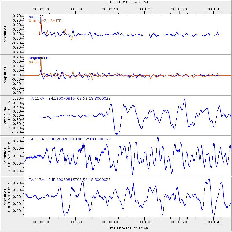
| Earthquake location: |
Solomon Islands |
| Earthquake latitude/longitude: |
-9.8/159.5 |
| Earthquake time(UTC): |
2007/08/16 (228) 08:39:27 GMT |
| Earthquake Depth: |
10 km |
| Earthquake Magnitude: |
6.1 MB, 6.7 MS, 6.4 MW |
| Earthquake Catalog/Contributor: |
WHDF/NEIC |
|
| Network: |
TA USArray Transportable Network (new EarthScope stations) |
| Station: |
117A Oracle, AZ, USA |
| Lat/Lon: |
32.57 N/110.74 W |
| Elevation: |
1544 m |
|
| Distance: |
95.0 deg |
| Az: |
57.955 deg |
| Baz: |
261.623 deg |
| Ray Param: |
0.040887572 |
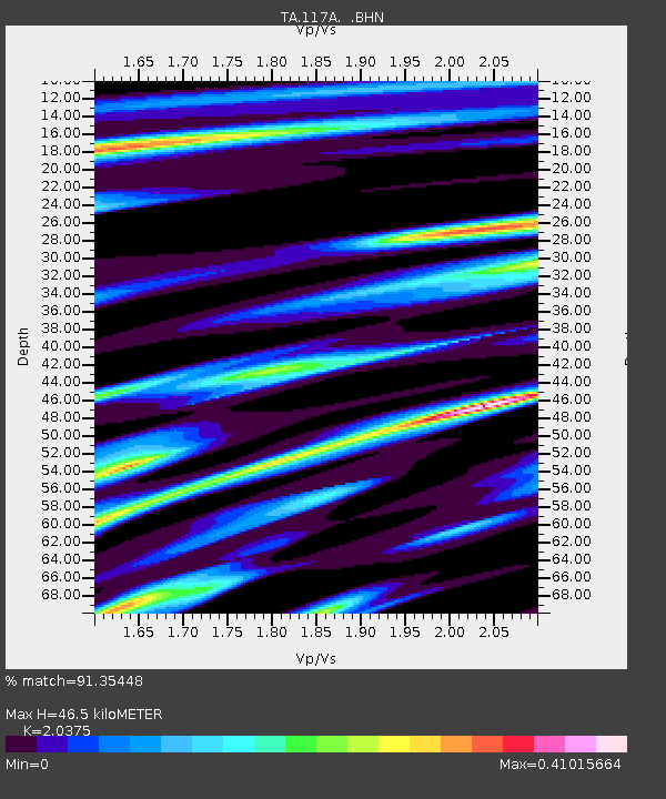
| Estimated Moho Depth: |
46.5 km |
| Estimated Crust Vp/Vs: |
2.04 |
| Assumed Crust Vp: |
6.276 km/s |
| Estimated Crust Vs: |
3.08 km/s |
| Estimated Crust Poisson's Ratio: |
0.34 |
|
| Radial Match: |
91.35448 % |
| Radial Bump: |
400 |
| Transverse Match: |
81.15301 % |
| Transverse Bump: |
400 |
| SOD ConfigId: |
2564 |
| Insert Time: |
2010-03-07 06:03:47.371 +0000 |
| GWidth: |
2.5 |
| Max Bumps: |
400 |
| Tol: |
0.001 |
|
Signal To Noise
| Channel | StoN | STA | LTA |
| TA:117A: :BHN:20070816T08:52:18.800002Z | 1.3190312 | 4.6820016E-8 | 3.549576E-8 |
| TA:117A: :BHE:20070816T08:52:18.800002Z | 0.9964828 | 3.840252E-8 | 3.8538065E-8 |
| TA:117A: :BHZ:20070816T08:52:18.800002Z | 1.6132933 | 1.0724197E-7 | 6.6473945E-8 |
| Arrivals |
| Ps | 7.8 SECOND |
| PpPs | 22 SECOND |
| PsPs/PpSs | 30 SECOND |


