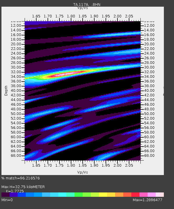
117A Oracle, AZ, USA - Earthquake Result Viewer
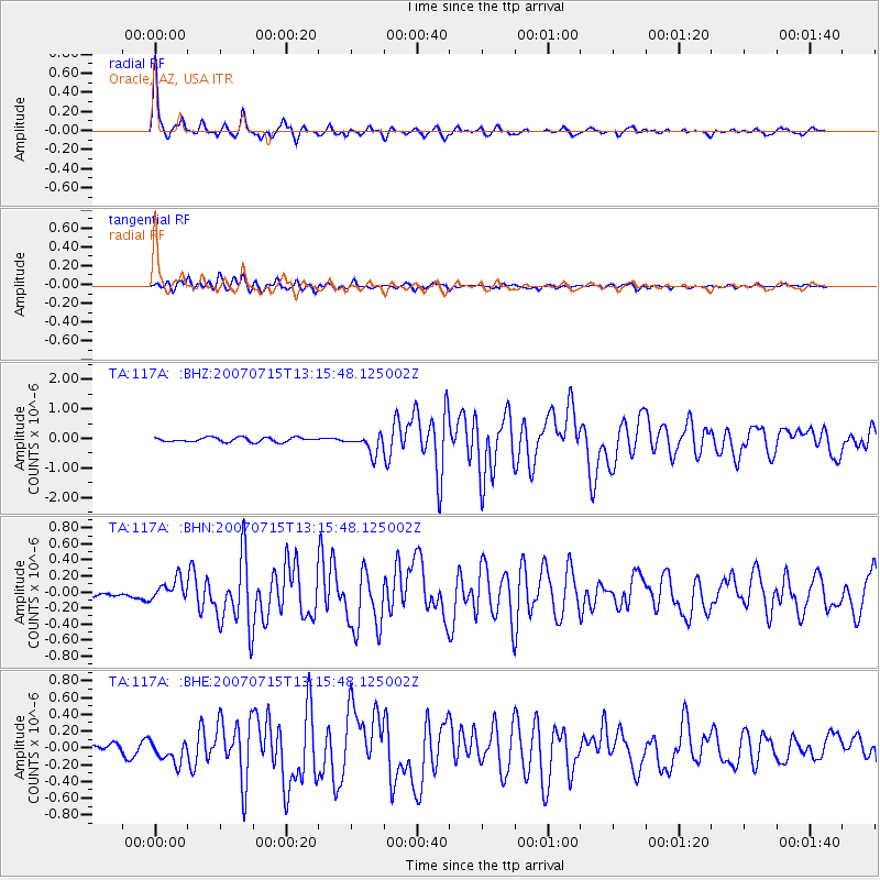
Earthquake location: Fox Islands, Aleutian Islands
Earthquake latitude/longitude: 52.5/-168.0
Earthquake time(UTC): 2007/07/15 (196) 13:08:00 GMT
Earthquake Depth: 10 km
Earthquake Magnitude: 5.8 MB, 5.9 MS, 6.1 MW, 6.0 MW
Earthquake Catalog/Contributor: WHDF/NEIC
Network: TA USArray Transportable Network (new EarthScope stations)
Station: 117A Oracle, AZ, USA
Lat/Lon: 32.57 N/110.74 W
Elevation: 1544 m
Distance: 45.3 deg
Az: 92.668 deg
Baz: 313.649 deg
Ray Param: 0.07133881
Estimated Moho Depth: 32.75 km
Estimated Crust Vp/Vs: 1.77
Assumed Crust Vp: 6.276 km/s
Estimated Crust Vs: 3.541 km/s
Estimated Crust Poisson's Ratio: 0.27
Radial Match: 96.216576 %
Radial Bump: 320
Transverse Match: 87.89316 %
Transverse Bump: 400
SOD ConfigId: 2564
Insert Time: 2010-03-07 06:03:59.788 +0000
GWidth: 2.5
Max Bumps: 400
Tol: 0.001

Signal To Noise

ChannelStoNSTALTA
TA:117A: :BHN:20070715T13:15:48.125002Z4.64696261.3043372E-72.8068595E-8
TA:117A: :BHE:20070715T13:15:48.125002Z2.76553251.3206868E-74.7755243E-8
TA:117A: :BHZ:20070715T13:15:48.125002Z4.268123.2427772E-77.5976715E-8
Arrivals
Ps4.3 SECOND
PpPs14 SECOND
PsPs/PpSs18 SECOND