You are here: Home > Network List > TA - USArray Transportable Network (new EarthScope stations) Stations List
> Station 117A Oracle, AZ, USA > Earthquake Result Viewer
117A Oracle, AZ, USA - Earthquake Result Viewer
| Earthquake location: |
Vanuatu Islands |
| Earthquake latitude/longitude: |
-15.4/168.6 |
| Earthquake time(UTC): |
2007/07/15 (196) 09:27:34 GMT |
| Earthquake Depth: |
8.0 km |
| Earthquake Magnitude: |
6.0 MB, 5.8 MS, 6.1 MW, 6.0 MW |
| Earthquake Catalog/Contributor: |
WHDF/NEIC |
|
| Network: |
TA USArray Transportable Network (new EarthScope stations) |
| Station: |
117A Oracle, AZ, USA |
| Lat/Lon: |
32.57 N/110.74 W |
| Elevation: |
1544 m |
|
| Distance: |
90.5 deg |
| Az: |
56.429 deg |
| Baz: |
252.155 deg |
| Ray Param: |
0.041667707 |
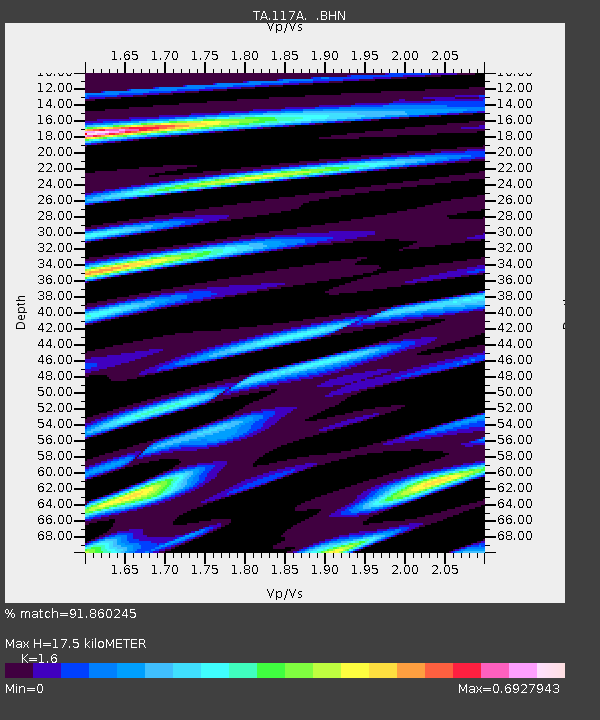
| Estimated Moho Depth: |
17.5 km |
| Estimated Crust Vp/Vs: |
1.60 |
| Assumed Crust Vp: |
6.276 km/s |
| Estimated Crust Vs: |
3.922 km/s |
| Estimated Crust Poisson's Ratio: |
0.18 |
|
| Radial Match: |
91.860245 % |
| Radial Bump: |
400 |
| Transverse Match: |
91.71753 % |
| Transverse Bump: |
400 |
| SOD ConfigId: |
2564 |
| Insert Time: |
2010-03-07 06:04:00.966 +0000 |
| GWidth: |
2.5 |
| Max Bumps: |
400 |
| Tol: |
0.001 |
|
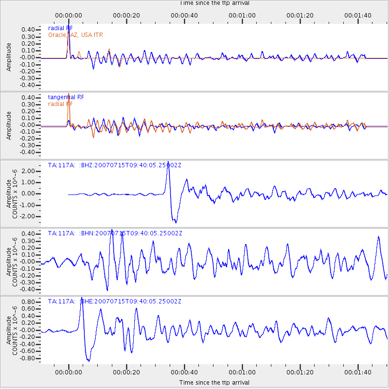
Signal To Noise
| Channel | StoN | STA | LTA |
| TA:117A: :BHN:20070715T09:40:05.25002Z | 2.1437547 | 5.2946078E-8 | 2.4697824E-8 |
| TA:117A: :BHE:20070715T09:40:05.25002Z | 7.561694 | 3.4328684E-7 | 4.539814E-8 |
| TA:117A: :BHZ:20070715T09:40:05.25002Z | 21.314081 | 1.0434424E-6 | 4.8955542E-8 |
| Arrivals |
| Ps | 1.7 SECOND |
| PpPs | 7.1 SECOND |
| PsPs/PpSs | 8.8 SECOND |


