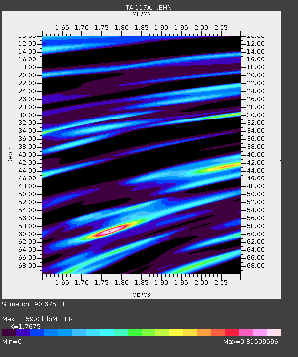
117A Oracle, AZ, USA - Earthquake Result Viewer
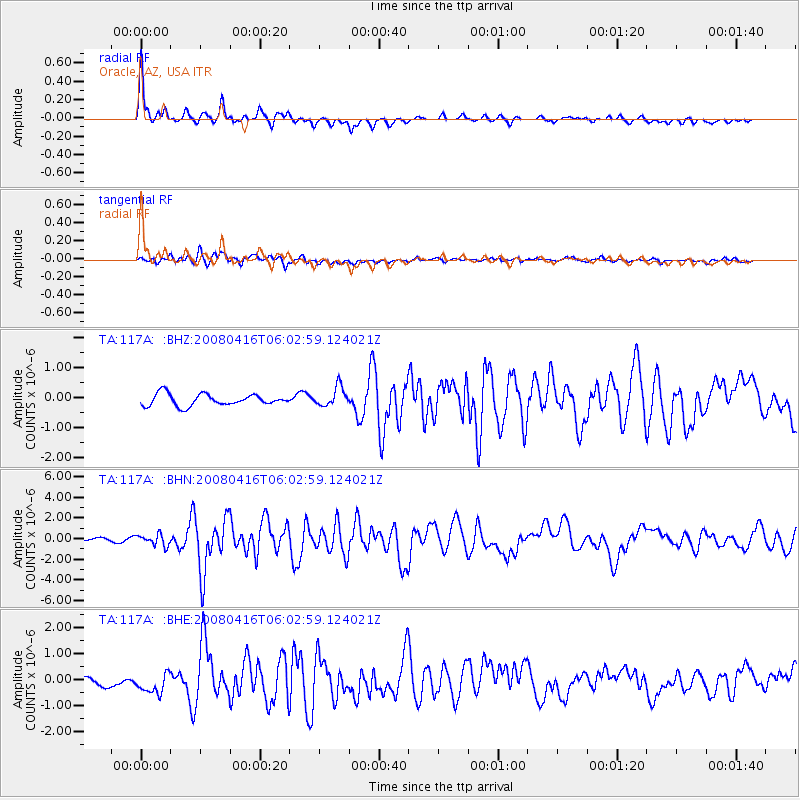
Earthquake location: Andreanof Islands, Aleutian Is.
Earthquake latitude/longitude: 51.9/-179.2
Earthquake time(UTC): 2008/04/16 (107) 05:54:19 GMT
Earthquake Depth: 13 km
Earthquake Magnitude: 6.1 MB, 6.5 MS, 6.6 MW, 6.6 MW
Earthquake Catalog/Contributor: WHDF/NEIC
Network: TA USArray Transportable Network (new EarthScope stations)
Station: 117A Oracle, AZ, USA
Lat/Lon: 32.57 N/110.74 W
Elevation: 1544 m
Distance: 52.2 deg
Az: 83.568 deg
Baz: 313.151 deg
Ray Param: 0.066903375
Estimated Moho Depth: 59.0 km
Estimated Crust Vp/Vs: 1.77
Assumed Crust Vp: 6.276 km/s
Estimated Crust Vs: 3.551 km/s
Estimated Crust Poisson's Ratio: 0.26
Radial Match: 90.67518 %
Radial Bump: 400
Transverse Match: 74.54412 %
Transverse Bump: 400
SOD ConfigId: 2504
Insert Time: 2010-03-07 06:04:11.387 +0000
GWidth: 2.5
Max Bumps: 400
Tol: 0.001

Signal To Noise

ChannelStoNSTALTA
TA:117A: :BHN:20080416T06:02:59.124021Z5.8039945.5055114E-79.4857285E-8
TA:117A: :BHE:20080416T06:02:59.124021Z2.88175734.1763528E-71.4492382E-7
TA:117A: :BHZ:20080416T06:02:59.124021Z1.67586673.2211113E-71.922057E-7
Arrivals
Ps7.6 SECOND
PpPs25 SECOND
PsPs/PpSs32 SECOND