You are here: Home > Network List > TA - USArray Transportable Network (new EarthScope stations) Stations List
> Station 117A Oracle, AZ, USA > Earthquake Result Viewer
117A Oracle, AZ, USA - Earthquake Result Viewer

| Earthquake location: |
Vanuatu Islands |
| Earthquake latitude/longitude: |
-19.9/169.0 |
| Earthquake time(UTC): |
2008/04/28 (119) 18:33:34 GMT |
| Earthquake Depth: |
32 km |
| Earthquake Magnitude: |
6.2 MB, 6.2 MS, 6.4 MW, 6.4 MW |
| Earthquake Catalog/Contributor: |
WHDF/NEIC |
|
| Network: |
TA USArray Transportable Network (new EarthScope stations) |
| Station: |
117A Oracle, AZ, USA |
| Lat/Lon: |
32.57 N/110.74 W |
| Elevation: |
1544 m |
|
| Distance: |
92.7 deg |
| Az: |
56.435 deg |
| Baz: |
248.189 deg |
| Ray Param: |
0.041387063 |
| Estimated Moho Depth: |
33.75 km |
| Estimated Crust Vp/Vs: |
1.65 |
| Assumed Crust Vp: |
6.276 km/s |
| Estimated Crust Vs: |
3.809 km/s |
| Estimated Crust Poisson's Ratio: |
0.21 |
|
| Radial Match: |
82.12292 % |
| Radial Bump: |
400 |
| Transverse Match: |
65.63458 % |
| Transverse Bump: |
400 |
| SOD ConfigId: |
2504 |
| Insert Time: |
2010-03-07 06:04:12.517 +0000 |
| GWidth: |
2.5 |
| Max Bumps: |
400 |
| Tol: |
0.001 |
|
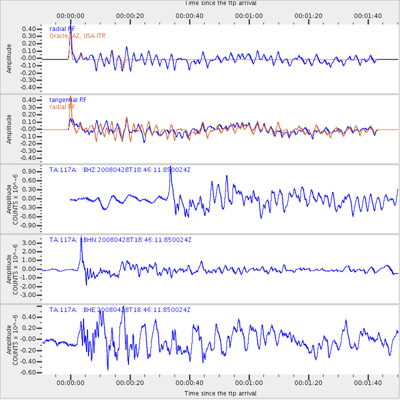
Signal To Noise
| Channel | StoN | STA | LTA |
| TA:117A: :BHN:20080428T18:46:11.850024Z | 8.892421 | 1.075249E-6 | 1.2091746E-7 |
| TA:117A: :BHE:20080428T18:46:11.850024Z | 1.985078 | 1.4341695E-7 | 7.2247516E-8 |
| TA:117A: :BHZ:20080428T18:46:11.850024Z | 3.2609072 | 3.4957037E-7 | 1.0720035E-7 |
| Arrivals |
| Ps | 3.6 SECOND |
| PpPs | 14 SECOND |
| PsPs/PpSs | 17 SECOND |


