You are here: Home > Network List > G - GEOSCOPE Stations List
> Station CLF Chambon la Foret observatory, France > Earthquake Result Viewer
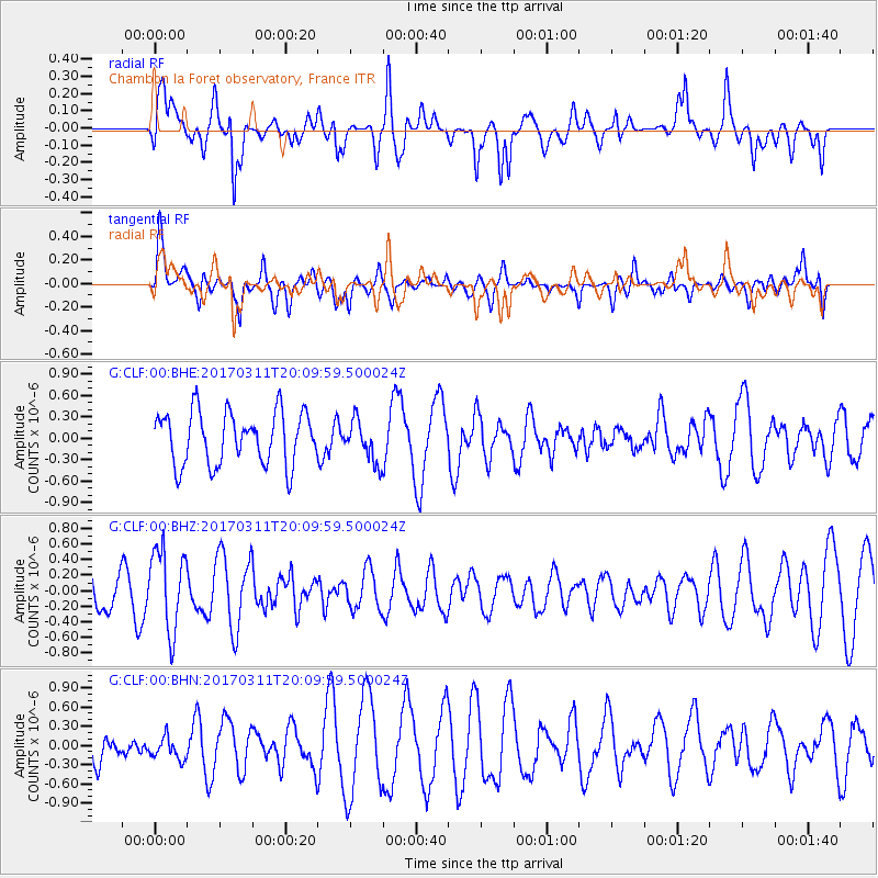
CLF Chambon la Foret observatory, France - Earthquake Result Viewer
*The percent match for this event was below the threshold and hence no stack was calculated.
| Earthquake location: |
Near East Coast Of Honshu, Japan |
| Earthquake latitude/longitude: |
37.5/141.5 |
| Earthquake time(UTC): |
2017/03/11 (070) 19:57:48 GMT |
| Earthquake Depth: |
44 km |
| Earthquake Magnitude: |
5.3 Mww |
| Earthquake Catalog/Contributor: |
NEIC PDE/us |
|
| Network: |
G GEOSCOPE |
| Station: |
CLF Chambon la Foret observatory, France |
| Lat/Lon: |
48.03 N/2.26 E |
| Elevation: |
145 m |
|
| Distance: |
87.4 deg |
| Az: |
333.985 deg |
| Baz: |
31.295 deg |
| Ray Param: |
$rayparam |
*The percent match for this event was below the threshold and hence was not used in the summary stack. |
|
| Radial Match: |
54.32003 % |
| Radial Bump: |
399 |
| Transverse Match: |
45.721325 % |
| Transverse Bump: |
400 |
| SOD ConfigId: |
1992691 |
| Insert Time: |
2017-03-25 19:59:03.977 +0000 |
| GWidth: |
2.5 |
| Max Bumps: |
400 |
| Tol: |
0.001 |
|
Signal To Noise
| Channel | StoN | STA | LTA |
| G:CLF:00:BHZ:20170311T20:09:59.500024Z | 2.2783103 | 5.2366363E-7 | 2.2984737E-7 |
| G:CLF:00:BHN:20170311T20:09:59.500024Z | 0.4722318 | 1.8039405E-7 | 3.8200318E-7 |
| G:CLF:00:BHE:20170311T20:09:59.500024Z | 0.7929734 | 2.9132673E-7 | 3.673852E-7 |
| Arrivals |
| Ps | |
| PpPs | |
| PsPs/PpSs | |


