You are here: Home > Network List > TA - USArray Transportable Network (new EarthScope stations) Stations List
> Station 117A Oracle, AZ, USA > Earthquake Result Viewer
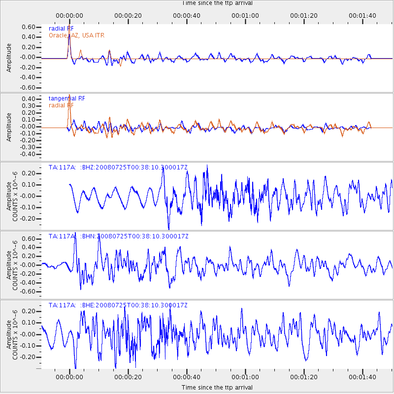
117A Oracle, AZ, USA - Earthquake Result Viewer
*The percent match for this event was below the threshold and hence no stack was calculated.
| Earthquake location: |
Rat Islands, Aleutian Islands |
| Earthquake latitude/longitude: |
51.3/179.0 |
| Earthquake time(UTC): |
2008/07/25 (207) 00:29:22 GMT |
| Earthquake Depth: |
21 km |
| Earthquake Magnitude: |
5.7 MB, 5.5 MS, 5.9 MW, 5.9 MW |
| Earthquake Catalog/Contributor: |
WHDF/NEIC |
|
| Network: |
TA USArray Transportable Network (new EarthScope stations) |
| Station: |
117A Oracle, AZ, USA |
| Lat/Lon: |
32.57 N/110.74 W |
| Elevation: |
1544 m |
|
| Distance: |
53.4 deg |
| Az: |
81.781 deg |
| Baz: |
312.589 deg |
| Ray Param: |
$rayparam |
*The percent match for this event was below the threshold and hence was not used in the summary stack. |
|
| Radial Match: |
67.566055 % |
| Radial Bump: |
400 |
| Transverse Match: |
47.407463 % |
| Transverse Bump: |
400 |
| SOD ConfigId: |
2504 |
| Insert Time: |
2010-03-07 06:04:18.616 +0000 |
| GWidth: |
2.5 |
| Max Bumps: |
400 |
| Tol: |
0.001 |
|
Signal To Noise
| Channel | StoN | STA | LTA |
| TA:117A: :BHN:20080725T00:38:10.300017Z | 4.223028 | 2.8930862E-7 | 6.850738E-8 |
| TA:117A: :BHE:20080725T00:38:10.300017Z | 1.9127766 | 1.2461575E-7 | 6.5149145E-8 |
| TA:117A: :BHZ:20080725T00:38:10.300017Z | 2.1956356 | 1.3271669E-7 | 6.0445686E-8 |
| Arrivals |
| Ps | |
| PpPs | |
| PsPs/PpSs | |


