You are here: Home > Network List > CI - Caltech Regional Seismic Network Stations List
> Station SMM Simmler, CA, USA > Earthquake Result Viewer
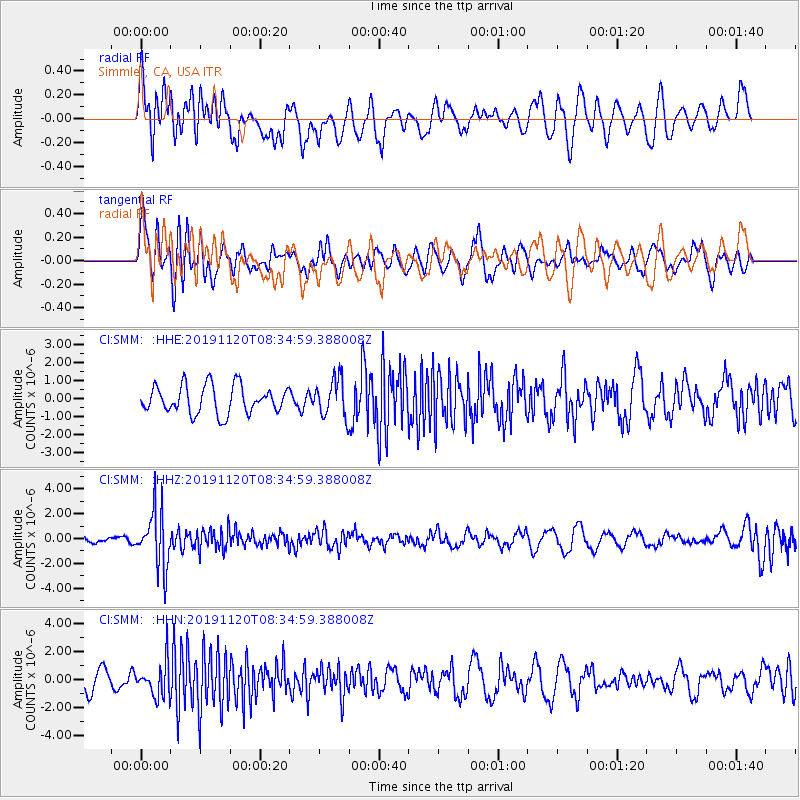
SMM Simmler, CA, USA - Earthquake Result Viewer
*The percent match for this event was below the threshold and hence no stack was calculated.
| Earthquake location: |
Sea Of Okhotsk |
| Earthquake latitude/longitude: |
53.2/153.7 |
| Earthquake time(UTC): |
2019/11/20 (324) 08:26:07 GMT |
| Earthquake Depth: |
487 km |
| Earthquake Magnitude: |
6.3 Mww |
| Earthquake Catalog/Contributor: |
NEIC PDE/us |
|
| Network: |
CI Caltech Regional Seismic Network |
| Station: |
SMM Simmler, CA, USA |
| Lat/Lon: |
35.31 N/120.00 W |
| Elevation: |
599 m |
|
| Distance: |
60.6 deg |
| Az: |
69.534 deg |
| Baz: |
316.388 deg |
| Ray Param: |
$rayparam |
*The percent match for this event was below the threshold and hence was not used in the summary stack. |
|
| Radial Match: |
55.49721 % |
| Radial Bump: |
400 |
| Transverse Match: |
55.464336 % |
| Transverse Bump: |
400 |
| SOD ConfigId: |
19951751 |
| Insert Time: |
2019-12-04 08:30:51.376 +0000 |
| GWidth: |
2.5 |
| Max Bumps: |
400 |
| Tol: |
0.001 |
|
Signal To Noise
| Channel | StoN | STA | LTA |
| CI:SMM: :HHZ:20191120T08:34:59.388008Z | 5.0204616 | 2.2926074E-6 | 4.5665269E-7 |
| CI:SMM: :HHN:20191120T08:34:59.388008Z | 1.7977477 | 1.226588E-6 | 6.8229144E-7 |
| CI:SMM: :HHE:20191120T08:34:59.388008Z | 1.3647275 | 1.0519242E-6 | 7.7079426E-7 |
| Arrivals |
| Ps | |
| PpPs | |
| PsPs/PpSs | |


