You are here: Home > Network List > TS - TERRAscope (Southern California Seismic Network) Stations List
> Station PAS Pasadena, California, USA > Earthquake Result Viewer
PAS Pasadena, California, USA - Earthquake Result Viewer
| Earthquake location: |
Alaska Peninsula |
| Earthquake latitude/longitude: |
55.2/-160.5 |
| Earthquake time(UTC): |
1993/05/13 (133) 11:59:49 GMT |
| Earthquake Depth: |
32 km |
| Earthquake Magnitude: |
6.4 MB, 6.8 MS, 6.8 UNKNOWN |
| Earthquake Catalog/Contributor: |
WHDF/NEIC |
|
| Network: |
TS TERRAscope (Southern California Seismic Network) |
| Station: |
PAS Pasadena, California, USA |
| Lat/Lon: |
34.15 N/118.17 W |
| Elevation: |
295 m |
|
| Distance: |
35.9 deg |
| Az: |
108.068 deg |
| Baz: |
318.885 deg |
| Ray Param: |
0.07689277 |
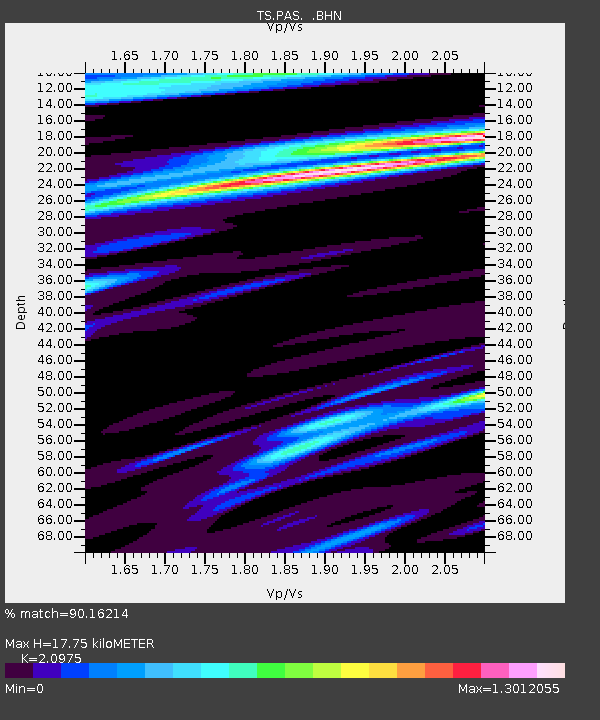
| Estimated Moho Depth: |
17.75 km |
| Estimated Crust Vp/Vs: |
2.10 |
| Assumed Crust Vp: |
6.1 km/s |
| Estimated Crust Vs: |
2.908 km/s |
| Estimated Crust Poisson's Ratio: |
0.35 |
|
| Radial Match: |
90.16214 % |
| Radial Bump: |
400 |
| Transverse Match: |
65.73983 % |
| Transverse Bump: |
400 |
| SOD ConfigId: |
16938 |
| Insert Time: |
2010-02-26 14:35:12.661 +0000 |
| GWidth: |
2.5 |
| Max Bumps: |
400 |
| Tol: |
0.001 |
|

Signal To Noise
| Channel | StoN | STA | LTA |
| TS:PAS: :BHN:19930513T12:06:16.296008Z | 1.4727434 | 3.898913E-7 | 2.6473813E-7 |
| TS:PAS: :BHE:19930513T12:06:16.296985Z | 1.5216684 | 5.1509727E-7 | 3.3850822E-7 |
| TS:PAS: :BHZ:19930513T12:06:16.296985Z | 5.962393 | 1.1730826E-6 | 1.9674695E-7 |
| Arrivals |
| Ps | 3.4 SECOND |
| PpPs | 8.5 SECOND |
| PsPs/PpSs | 12 SECOND |


