You are here: Home > Network List > TS - TERRAscope (Southern California Seismic Network) Stations List
> Station PAS Pasadena, California, USA > Earthquake Result Viewer
PAS Pasadena, California, USA - Earthquake Result Viewer
| Earthquake location: |
Hokkaido, Japan Region |
| Earthquake latitude/longitude: |
43.0/144.2 |
| Earthquake time(UTC): |
1993/01/15 (015) 11:06:00 GMT |
| Earthquake Depth: |
100 km |
| Earthquake Magnitude: |
6.0 MB |
| Earthquake Catalog/Contributor: |
WHDF/NEIC |
|
| Network: |
TS TERRAscope (Southern California Seismic Network) |
| Station: |
PAS Pasadena, California, USA |
| Lat/Lon: |
34.15 N/118.17 W |
| Elevation: |
295 m |
|
| Distance: |
72.6 deg |
| Az: |
59.46 deg |
| Baz: |
310.351 deg |
| Ray Param: |
0.053300515 |
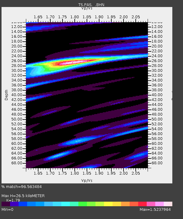
| Estimated Moho Depth: |
26.5 km |
| Estimated Crust Vp/Vs: |
1.79 |
| Assumed Crust Vp: |
6.1 km/s |
| Estimated Crust Vs: |
3.408 km/s |
| Estimated Crust Poisson's Ratio: |
0.27 |
|
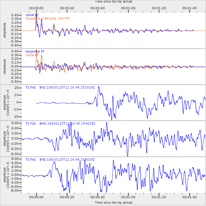
| Radial Match: |
96.563484 % |
| Radial Bump: |
400 |
| Transverse Match: |
86.03587 % |
| Transverse Bump: |
400 |
| SOD ConfigId: |
16938 |
| Insert Time: |
2010-02-26 14:35:15.143 +0000 |
| GWidth: |
2.5 |
| Max Bumps: |
400 |
| Tol: |
0.001 |
|
Signal To Noise
| Channel | StoN | STA | LTA |
| TS:PAS: :BHN:19930115T11:16:46.254028Z | 1.8083941 | 5.252643E-7 | 2.9045898E-7 |
| TS:PAS: :BHE:19930115T11:16:46.254028Z | 0.8345726 | 2.189588E-7 | 2.623604E-7 |
| TS:PAS: :BHZ:19930115T11:16:46.252014Z | 2.2687156 | 8.4447197E-7 | 3.7222472E-7 |
| Arrivals |
| Ps | 3.5 SECOND |
| PpPs | 12 SECOND |
| PsPs/PpSs | 15 SECOND |


