You are here: Home > Network List > TS - TERRAscope (Southern California Seismic Network) Stations List
> Station PAS Pasadena, California, USA > Earthquake Result Viewer
PAS Pasadena, California, USA - Earthquake Result Viewer
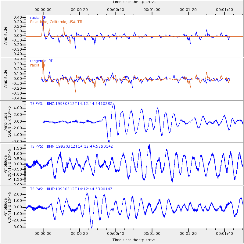
| Earthquake location: |
Fiji Islands Region |
| Earthquake latitude/longitude: |
-14.3/-178.3 |
| Earthquake time(UTC): |
1993/03/12 (071) 14:01:38 GMT |
| Earthquake Depth: |
33 km |
| Earthquake Magnitude: |
5.9 MB, 6.5 MS |
| Earthquake Catalog/Contributor: |
WHDF/NEIC |
|
| Network: |
TS TERRAscope (Southern California Seismic Network) |
| Station: |
PAS Pasadena, California, USA |
| Lat/Lon: |
34.15 N/118.17 W |
| Elevation: |
295 m |
|
| Distance: |
74.8 deg |
| Az: |
48.187 deg |
| Baz: |
240.579 deg |
| Ray Param: |
0.05206541 |
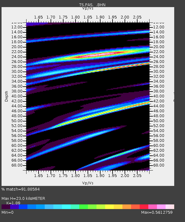
| Estimated Moho Depth: |
23.0 km |
| Estimated Crust Vp/Vs: |
1.89 |
| Assumed Crust Vp: |
6.1 km/s |
| Estimated Crust Vs: |
3.228 km/s |
| Estimated Crust Poisson's Ratio: |
0.31 |
|
| Radial Match: |
91.88594 % |
| Radial Bump: |
334 |
| Transverse Match: |
84.6263 % |
| Transverse Bump: |
400 |
| SOD ConfigId: |
16938 |
| Insert Time: |
2010-02-26 14:35:16.292 +0000 |
| GWidth: |
2.5 |
| Max Bumps: |
400 |
| Tol: |
0.001 |
|
Signal To Noise
| Channel | StoN | STA | LTA |
| TS:PAS: :BHN:19930312T14:12:44.539014Z | 1.3722379 | 3.1043703E-7 | 2.2622682E-7 |
| TS:PAS: :BHE:19930312T14:12:44.539014Z | 1.280423 | 2.4826636E-7 | 1.9389402E-7 |
| TS:PAS: :BHZ:19930312T14:12:44.541028Z | 4.7335534 | 7.780012E-7 | 1.6435881E-7 |
| Arrivals |
| Ps | 3.4 SECOND |
| PpPs | 11 SECOND |
| PsPs/PpSs | 14 SECOND |


