You are here: Home > Network List > TA - USArray Transportable Network (new EarthScope stations) Stations List
> Station Z15A Gila River Indian Community, Laveen, AZ, USA > Earthquake Result Viewer
Z15A Gila River Indian Community, Laveen, AZ, USA - Earthquake Result Viewer
| Earthquake location: |
Peru-Brazil Border Region |
| Earthquake latitude/longitude: |
-7.6/-74.4 |
| Earthquake time(UTC): |
2008/08/26 (239) 21:00:36 GMT |
| Earthquake Depth: |
154 km |
| Earthquake Magnitude: |
6.0 MB, 6.4 MW, 6.4 MW |
| Earthquake Catalog/Contributor: |
WHDF/NEIC |
|
| Network: |
TA USArray Transportable Network (new EarthScope stations) |
| Station: |
Z15A Gila River Indian Community, Laveen, AZ, USA |
| Lat/Lon: |
33.29 N/112.16 W |
| Elevation: |
318 m |
|
| Distance: |
54.3 deg |
| Az: |
320.79 deg |
| Baz: |
131.571 deg |
| Ray Param: |
0.06505175 |
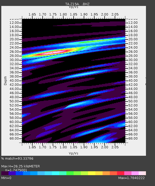
| Estimated Moho Depth: |
26.25 km |
| Estimated Crust Vp/Vs: |
1.75 |
| Assumed Crust Vp: |
6.264 km/s |
| Estimated Crust Vs: |
3.584 km/s |
| Estimated Crust Poisson's Ratio: |
0.26 |
|
| Radial Match: |
93.33796 % |
| Radial Bump: |
399 |
| Transverse Match: |
86.08357 % |
| Transverse Bump: |
400 |
| SOD ConfigId: |
2504 |
| Insert Time: |
2010-03-07 06:05:18.140 +0000 |
| GWidth: |
2.5 |
| Max Bumps: |
400 |
| Tol: |
0.001 |
|

Signal To Noise
| Channel | StoN | STA | LTA |
| TA:Z15A: :BHZ:20080826T21:09:16.050002Z | 8.273203 | 1.4421882E-6 | 1.7432042E-7 |
| TA:Z15A: :BHN:20080826T21:09:16.050002Z | 4.4910173 | 5.731977E-7 | 1.2763203E-7 |
| TA:Z15A: :BHE:20080826T21:09:16.050002Z | 5.2663045 | 6.8344684E-7 | 1.297773E-7 |
| Arrivals |
| Ps | 3.3 SECOND |
| PpPs | 11 SECOND |
| PsPs/PpSs | 14 SECOND |


