You are here: Home > Network List > NM - Cooperative New Madrid Seismic Network Stations List
> Station PARM Stahl Farm,MO > Earthquake Result Viewer
PARM Stahl Farm,MO - Earthquake Result Viewer
| Earthquake location: |
Sea Of Okhotsk |
| Earthquake latitude/longitude: |
53.2/153.7 |
| Earthquake time(UTC): |
2019/11/20 (324) 08:26:07 GMT |
| Earthquake Depth: |
487 km |
| Earthquake Magnitude: |
6.3 Mww |
| Earthquake Catalog/Contributor: |
NEIC PDE/us |
|
| Network: |
NM Cooperative New Madrid Seismic Network |
| Station: |
PARM Stahl Farm,MO |
| Lat/Lon: |
36.66 N/89.75 W |
| Elevation: |
85 m |
|
| Distance: |
75.0 deg |
| Az: |
48.11 deg |
| Baz: |
326.12 deg |
| Ray Param: |
0.050433297 |
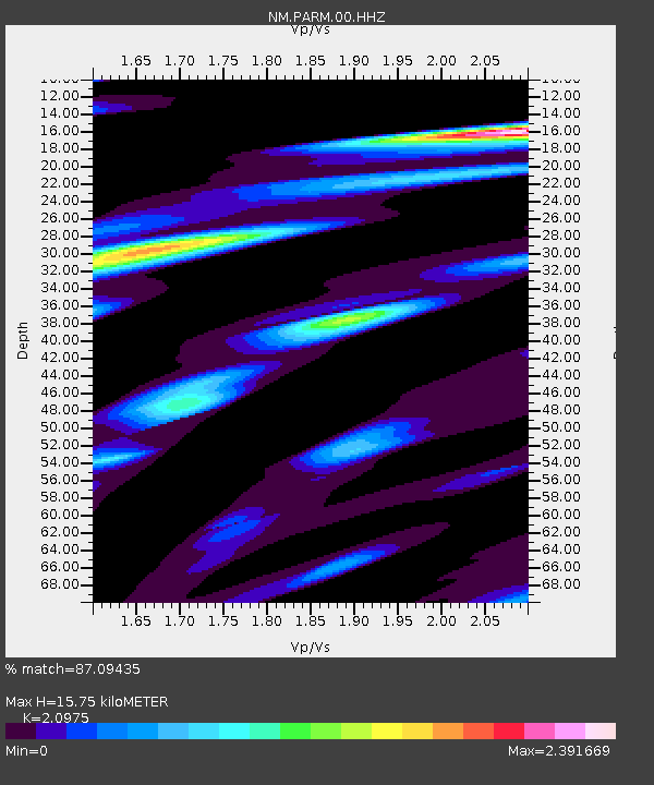
| Estimated Moho Depth: |
15.75 km |
| Estimated Crust Vp/Vs: |
2.10 |
| Assumed Crust Vp: |
6.444 km/s |
| Estimated Crust Vs: |
3.072 km/s |
| Estimated Crust Poisson's Ratio: |
0.35 |
|
| Radial Match: |
87.09435 % |
| Radial Bump: |
388 |
| Transverse Match: |
67.176476 % |
| Transverse Bump: |
400 |
| SOD ConfigId: |
19951751 |
| Insert Time: |
2019-12-04 08:34:39.460 +0000 |
| GWidth: |
2.5 |
| Max Bumps: |
400 |
| Tol: |
0.001 |
|

Signal To Noise
| Channel | StoN | STA | LTA |
| NM:PARM:00:HHZ:20191120T08:36:27.539986Z | 12.411154 | 1.8223038E-6 | 1.4682792E-7 |
| NM:PARM:00:HHN:20191120T08:36:27.539986Z | 2.6424847 | 8.658258E-7 | 3.2765595E-7 |
| NM:PARM:00:HHE:20191120T08:36:27.539986Z | 1.5259467 | 5.519989E-7 | 3.6174194E-7 |
| Arrivals |
| Ps | 2.8 SECOND |
| PpPs | 7.4 SECOND |
| PsPs/PpSs | 10 SECOND |


