You are here: Home > Network List > TA - USArray Transportable Network (new EarthScope stations) Stations List
> Station Z15A Gila River Indian Community, Laveen, AZ, USA > Earthquake Result Viewer
Z15A Gila River Indian Community, Laveen, AZ, USA - Earthquake Result Viewer

| Earthquake location: |
Chile-Bolivia Border Region |
| Earthquake latitude/longitude: |
-20.0/-69.0 |
| Earthquake time(UTC): |
2008/03/24 (084) 20:39:07 GMT |
| Earthquake Depth: |
120 km |
| Earthquake Magnitude: |
5.7 MB, 6.2 MW, 6.1 MW |
| Earthquake Catalog/Contributor: |
WHDF/NEIC |
|
| Network: |
TA USArray Transportable Network (new EarthScope stations) |
| Station: |
Z15A Gila River Indian Community, Laveen, AZ, USA |
| Lat/Lon: |
33.29 N/112.16 W |
| Elevation: |
318 m |
|
| Distance: |
67.2 deg |
| Az: |
321.534 deg |
| Baz: |
135.715 deg |
| Ray Param: |
0.056811154 |
| Estimated Moho Depth: |
26.0 km |
| Estimated Crust Vp/Vs: |
1.77 |
| Assumed Crust Vp: |
6.264 km/s |
| Estimated Crust Vs: |
3.534 km/s |
| Estimated Crust Poisson's Ratio: |
0.27 |
|
| Radial Match: |
85.968216 % |
| Radial Bump: |
400 |
| Transverse Match: |
71.40493 % |
| Transverse Bump: |
400 |
| SOD ConfigId: |
2564 |
| Insert Time: |
2010-03-07 06:05:23.231 +0000 |
| GWidth: |
2.5 |
| Max Bumps: |
400 |
| Tol: |
0.001 |
|
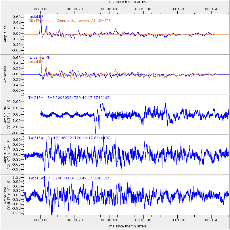
Signal To Noise
| Channel | StoN | STA | LTA |
| TA:Z15A: :BHN:20080324T20:49:17.874019Z | 2.3953183 | 3.7776383E-7 | 1.5770924E-7 |
| TA:Z15A: :BHE:20080324T20:49:17.874019Z | 2.5506637 | 4.4759906E-7 | 1.7548336E-7 |
| TA:Z15A: :BHZ:20080324T20:49:17.874019Z | 4.481614 | 9.431219E-7 | 2.1044245E-7 |
| Arrivals |
| Ps | 3.3 SECOND |
| PpPs | 11 SECOND |
| PsPs/PpSs | 14 SECOND |


