You are here: Home > Network List > TA - USArray Transportable Network (new EarthScope stations) Stations List
> Station Z15A Gila River Indian Community, Laveen, AZ, USA > Earthquake Result Viewer
Z15A Gila River Indian Community, Laveen, AZ, USA - Earthquake Result Viewer
| Earthquake location: |
Solomon Islands |
| Earthquake latitude/longitude: |
-10.9/162.1 |
| Earthquake time(UTC): |
2007/11/27 (331) 11:49:58 GMT |
| Earthquake Depth: |
16 km |
| Earthquake Magnitude: |
5.9 MB, 6.7 MS, 6.6 MW, 6.4 MW |
| Earthquake Catalog/Contributor: |
WHDF/NEIC |
|
| Network: |
TA USArray Transportable Network (new EarthScope stations) |
| Station: |
Z15A Gila River Indian Community, Laveen, AZ, USA |
| Lat/Lon: |
33.29 N/112.16 W |
| Elevation: |
318 m |
|
| Distance: |
92.4 deg |
| Az: |
56.714 deg |
| Baz: |
258.549 deg |
| Ray Param: |
0.04146668 |
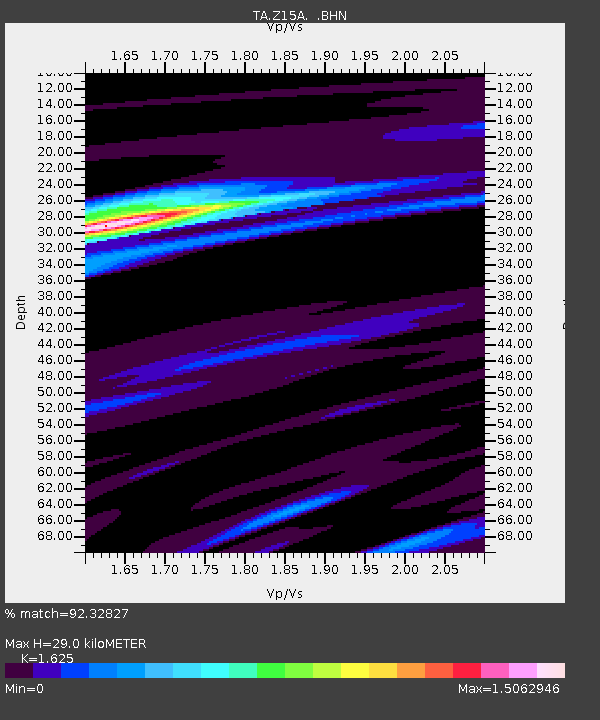
| Estimated Moho Depth: |
29.0 km |
| Estimated Crust Vp/Vs: |
1.62 |
| Assumed Crust Vp: |
6.264 km/s |
| Estimated Crust Vs: |
3.855 km/s |
| Estimated Crust Poisson's Ratio: |
0.20 |
|
| Radial Match: |
92.32827 % |
| Radial Bump: |
400 |
| Transverse Match: |
60.32751 % |
| Transverse Bump: |
400 |
| SOD ConfigId: |
2564 |
| Insert Time: |
2010-03-07 06:05:37.674 +0000 |
| GWidth: |
2.5 |
| Max Bumps: |
400 |
| Tol: |
0.001 |
|
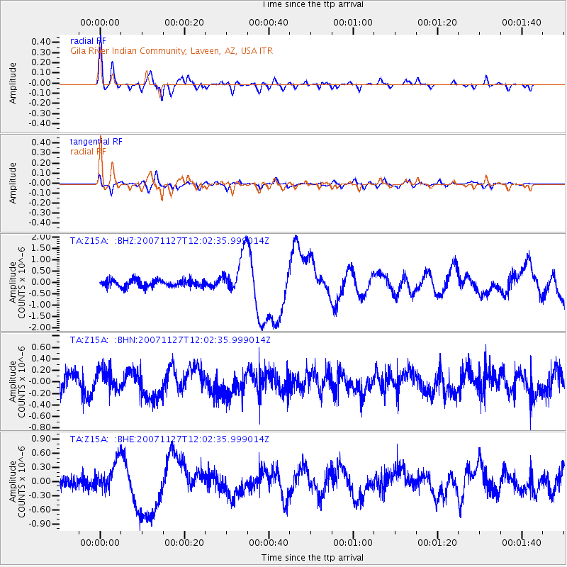
Signal To Noise
| Channel | StoN | STA | LTA |
| TA:Z15A: :BHN:20071127T12:02:35.999014Z | 1.1627218 | 1.7971956E-7 | 1.5456799E-7 |
| TA:Z15A: :BHE:20071127T12:02:35.999014Z | 2.6002572 | 3.2135944E-7 | 1.2358755E-7 |
| TA:Z15A: :BHZ:20071127T12:02:35.999014Z | 5.903795 | 9.295758E-7 | 1.5745395E-7 |
| Arrivals |
| Ps | 3.0 SECOND |
| PpPs | 12 SECOND |
| PsPs/PpSs | 15 SECOND |


