You are here: Home > Network List > TS - TERRAscope (Southern California Seismic Network) Stations List
> Station PAS Pasadena, California, USA > Earthquake Result Viewer
PAS Pasadena, California, USA - Earthquake Result Viewer

| Earthquake location: |
San Juan Province, Argentina |
| Earthquake latitude/longitude: |
-31.6/-69.2 |
| Earthquake time(UTC): |
1993/06/08 (159) 23:17:41 GMT |
| Earthquake Depth: |
113 km |
| Earthquake Magnitude: |
6.4 MB, 6.4 UNKNOWN |
| Earthquake Catalog/Contributor: |
WHDF/NEIC |
|
| Network: |
TS TERRAscope (Southern California Seismic Network) |
| Station: |
PAS Pasadena, California, USA |
| Lat/Lon: |
34.15 N/118.17 W |
| Elevation: |
295 m |
|
| Distance: |
80.0 deg |
| Az: |
320.576 deg |
| Baz: |
139.199 deg |
| Ray Param: |
0.04831159 |
| Estimated Moho Depth: |
57.0 km |
| Estimated Crust Vp/Vs: |
2.10 |
| Assumed Crust Vp: |
6.1 km/s |
| Estimated Crust Vs: |
2.908 km/s |
| Estimated Crust Poisson's Ratio: |
0.35 |
|
| Radial Match: |
90.43729 % |
| Radial Bump: |
400 |
| Transverse Match: |
86.7329 % |
| Transverse Bump: |
400 |
| SOD ConfigId: |
16938 |
| Insert Time: |
2010-02-26 14:35:19.895 +0000 |
| GWidth: |
2.5 |
| Max Bumps: |
400 |
| Tol: |
0.001 |
|
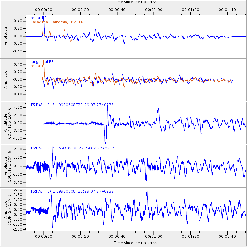
Signal To Noise
| Channel | StoN | STA | LTA |
| TS:PAS: :BHN:19930608T23:29:07.274023Z | 5.210696 | 7.790986E-7 | 1.4951911E-7 |
| TS:PAS: :BHE:19930608T23:29:07.274023Z | 4.4485345 | 7.714461E-7 | 1.7341578E-7 |
| TS:PAS: :BHZ:19930608T23:29:07.274023Z | 16.900984 | 2.3856476E-6 | 1.4115436E-7 |
| Arrivals |
| Ps | 10 SECOND |
| PpPs | 28 SECOND |
| PsPs/PpSs | 39 SECOND |


