You are here: Home > Network List > TA - USArray Transportable Network (new EarthScope stations) Stations List
> Station Z15A Gila River Indian Community, Laveen, AZ, USA > Earthquake Result Viewer
Z15A Gila River Indian Community, Laveen, AZ, USA - Earthquake Result Viewer
| Earthquake location: |
Fiji Islands Region |
| Earthquake latitude/longitude: |
-21.2/-178.8 |
| Earthquake time(UTC): |
2007/11/19 (323) 00:52:12 GMT |
| Earthquake Depth: |
558 km |
| Earthquake Magnitude: |
6.2 MB, 6.3 MW, 6.3 MW |
| Earthquake Catalog/Contributor: |
WHDF/NEIC |
|
| Network: |
TA USArray Transportable Network (new EarthScope stations) |
| Station: |
Z15A Gila River Indian Community, Laveen, AZ, USA |
| Lat/Lon: |
33.29 N/112.16 W |
| Elevation: |
318 m |
|
| Distance: |
83.4 deg |
| Az: |
50.691 deg |
| Baz: |
239.551 deg |
| Ray Param: |
0.04454987 |
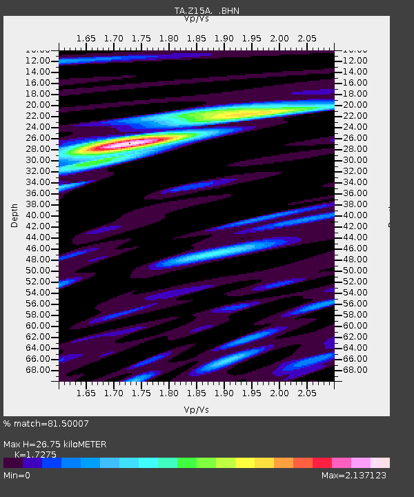
| Estimated Moho Depth: |
26.75 km |
| Estimated Crust Vp/Vs: |
1.73 |
| Assumed Crust Vp: |
6.264 km/s |
| Estimated Crust Vs: |
3.626 km/s |
| Estimated Crust Poisson's Ratio: |
0.25 |
|
| Radial Match: |
81.50007 % |
| Radial Bump: |
400 |
| Transverse Match: |
69.95296 % |
| Transverse Bump: |
400 |
| SOD ConfigId: |
2564 |
| Insert Time: |
2010-03-07 06:05:39.081 +0000 |
| GWidth: |
2.5 |
| Max Bumps: |
400 |
| Tol: |
0.001 |
|

Signal To Noise
| Channel | StoN | STA | LTA |
| TA:Z15A: :BHN:20071119T01:03:10.450002Z | 1.3031082 | 2.8636225E-7 | 2.1975323E-7 |
| TA:Z15A: :BHE:20071119T01:03:10.450002Z | 3.2739563 | 6.268702E-7 | 1.9147177E-7 |
| TA:Z15A: :BHZ:20071119T01:03:10.450002Z | 13.072543 | 1.7334525E-6 | 1.3260255E-7 |
| Arrivals |
| Ps | 3.2 SECOND |
| PpPs | 11 SECOND |
| PsPs/PpSs | 15 SECOND |


