You are here: Home > Network List > RM - Regional Integrated Multi Hazard Early Warning System Stations List
> Station SZP Santa Ilocos Sur > Earthquake Result Viewer
SZP Santa Ilocos Sur - Earthquake Result Viewer
| Earthquake location: |
Sea Of Okhotsk |
| Earthquake latitude/longitude: |
53.2/153.7 |
| Earthquake time(UTC): |
2019/11/20 (324) 08:26:07 GMT |
| Earthquake Depth: |
487 km |
| Earthquake Magnitude: |
6.3 Mww |
| Earthquake Catalog/Contributor: |
NEIC PDE/us |
|
| Network: |
RM Regional Integrated Multi Hazard Early Warning System |
| Station: |
SZP Santa Ilocos Sur |
| Lat/Lon: |
17.55 N/120.46 E |
| Elevation: |
100 m |
|
| Distance: |
44.0 deg |
| Az: |
228.863 deg |
| Baz: |
28.381 deg |
| Ray Param: |
0.069925934 |
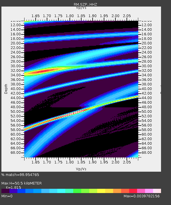
| Estimated Moho Depth: |
50.5 km |
| Estimated Crust Vp/Vs: |
1.82 |
| Assumed Crust Vp: |
6.468 km/s |
| Estimated Crust Vs: |
3.563 km/s |
| Estimated Crust Poisson's Ratio: |
0.28 |
|
| Radial Match: |
99.954765 % |
| Radial Bump: |
12 |
| Transverse Match: |
63.232693 % |
| Transverse Bump: |
400 |
| SOD ConfigId: |
19951751 |
| Insert Time: |
2019-12-04 08:36:19.179 +0000 |
| GWidth: |
2.5 |
| Max Bumps: |
400 |
| Tol: |
0.001 |
|

Signal To Noise
| Channel | StoN | STA | LTA |
| RM:SZP: :HHZ:20191120T08:32:59.918007Z | 6.1313276 | 1.1086962E-5 | 1.8082483E-6 |
| RM:SZP: :HHN:20191120T08:32:59.918007Z | 4.8524446 | 6.8806808E-6 | 1.4179823E-6 |
| RM:SZP: :HHE:20191120T08:32:59.918007Z | 8.39092 | 7.740886E-6 | 9.2253117E-7 |
| Arrivals |
| Ps | 6.8 SECOND |
| PpPs | 21 SECOND |
| PsPs/PpSs | 27 SECOND |


